
United States, North America
Showing 157–195 of 386 results
-

Map, New York City, Pictorial, Historical, National City Bank, Vintage Print, 1932 (Sold)
-

Map, New York City, Pictorial, Manhattan, Paul Savitt, Vintage Print, 1946
$600 -

Map, New York City, Pictorial, Pakay, Vintage Print, 1939
-

Map, New York City, Pictorial, SoHo, Russo, Vintage Poster, 1986
$575 -
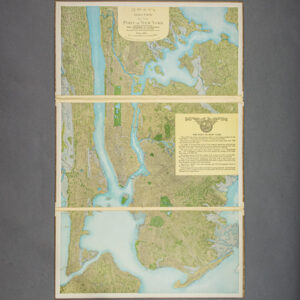
Map, New York City, Port of New York Aero View, C.P. Gray, Antique Print, 1912
$2,300 -

Map, New York City, Promotional Advertising Broadside, Antique Wall Map, c. 1865
$2,900 -

Map, New York City, The Great Metropolis, Antique, Taintor Brothers, New York, 1867
$1,250 -

Map, New York City, Upper East Side, Upper West Side, Broadside Real Estate Plat, Antique1852
$1,250 -
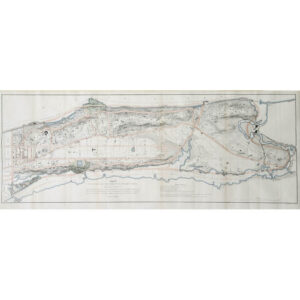
Map, New York City, Upper Manhattan, Antique Print, New York, c. 1868
-

Map, New York Metropolitan Area, Golf Courses, Rand McNally, Antique Print, 1923
-

Map, New York State, Bedford, F.W. Beers, Antique Print, 1867
$300 -

Map, New York State, Ensign, Bridgman & Fanning, Antique Illustrated Map, 1855
$3,500 -

Map, New York State, J.H. Eddy, Antique Wall Map, New York, 1818
$3,200 -

Map, New York State, Wall Map, Sherman & Smith, Ensign & Thayer, Antique Print, 1851
$2,725 -

Map, New York State, Westchester County, Pictorial, Historical, Vintage Print, 1950
-

Map, New York State, Westchester County, Pictorial, Revolutionary War, Vintage Print, 1933
$600 -

Map, New York, Long Island, LIRR, Antique Print, 1907
$600 -

Map, New York, New England, Various Sea Charts, Sailing, George Eldridge, Early 20th C.
$375 -

Map, New York, Pictorial, American Indian History of New York State, Vintage Print, 1935
-

Map, North America, Pictorial, Ernest Dudley Chase, Vintage Print, 1945
-
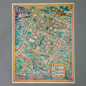
Map, North Carolina, Pictorial, University of North Carolina Chapel Hill, Louise and Sydney Britton, Vintage Print, 1962
$3,500 -

Map, North Pole, William Bauman, New York, Late 19th Century
$1,200 -

Map, Novelty, Gulf Stream, Atlantic Ocean, Navigation, Antique Print, Philadelphia, 1799
$950 -

Map, Novelty, Railroad, Soo Line Railroad Tray, Cartographic Curiosity, c. 1913-20
$1,600 -
![Norris' Map of the United States of America together with adjacent portions of the Dominion of Canada and the United States of Mexico [Zylo-Karta Games]](https://www.georgeglazer.com/wpmain/wp-content/uploads/2018/05/zylokarta1-300x300.jpg)
Map, Novelty, United States, Zylo-Karta Game, Cartographic Curiosity, Antique, New York, 1884
$1,200 -

Map, Oregon, Pictorial, Doris Wildman, Vintage Print, c. 1929
$2,250 -

Map, Oregon, Pictorial, Keep Oregon Green: The Beaver State, H.J. Hayes, Vintage Print, 1962
$225 -

Map, Pennsylvania, Anthony Finley, Antique Wall Map, Philadelphia, 1829
$975 -

Map, Pennsylvania, Berks County, Pictorial, Vintage Print, 1947
$600 -

Map, Pennsylvania, Philadelphia, Pictorial, University of Pennsylvania, Vintage Print, 1933
-

Map, Pennsylvania, Pictorial, Ensign, Bridgeman and Fanning, Antique Print, New York, 1855
$3,500 -

Map, Pennsylvania, Pocket Map, Antique, Colton, New York, 1878
$325 -

Map, Pictorial, Aviation, Amy Drevenstedt, Lindbergh Transatlantic Flight, c. 1927
-

Map, Pictorial, Aviation, Ernest Clegg, Lindbergh Transatlantic Flight, c. 1928
$2,750 -

Map, Pictorial, Long Island and Eastern Seaboard, Sunken Treasure, Melbourne Brindle, Vintage Print, 1958
$950 -

Map, Pictorial, Missouri, St. Louis, Frank Nuderscher, 1935
$650 -

Map, Rock Island Line Railroad, President’s Custom Boxed Set of 15 State Maps, c. 1922-33
$4,800 -

Map, Shelter Island, New York, Pictorial, Edith Shepard, Vintage Print, 1950
$1,400 -
![Florida, et Regiones Vincinae [Florida and Vicinity] from Beschrijvinghe van West-Indiën](https://www.georgeglazer.com/wpmain/wp-content/uploads/2017/02/delaet-florida-300x300.jpg)
Map, Southeastern United States, Florida, West Indies, De Laet, Antique Print, Dutch, 1630
$4,800