
Specialty Maps
Showing 1–39 of 40 results
-

Advertising Art, Beer Brewery, Hyde Park Game Bird Map, St. Louis, Vintage Poster, 1941
$3,600 -

Astronomy, Diagram, Armillary Sphere, Orrery, Antique Print, Lotter, Augsburg,1774
$1,900 -

Astronomy, Diagram, Astrology, Planets, Pro Crisibus Morborum, Zahn, Antique Map, 1696
$1,200 -

Astronomy, Diagram, Coronelli, Marly Baroque Globes, Antique Print, Venice, 1689
$3,200 -

Book, Reference, Cartography, Pictorial Maps, You Are Here NYC, Katharine Harmon, 2016
-

Fine Art, Modern, Pictorial Map, Kidnapping Kissinger, Oyvind Fahlstrom, Screenprint, 1974
-

History, American, Indians and First Settlers, Native Americans, Antique Chart on Rollers, 1850s
$2,750 -

History, Exploration, Hakluyt Voyages, Thomas Derrick, Antique Drawings, 1927
$9,800 -
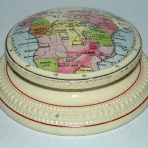
Map, Africa, Cartographic Curiosity, Antique Ceramic Paperweight, c. 1889-99
-

Map, Atlas Frontis Page, Antique Print, Homann, Nuremberg, 1737
$450 -

Map, Australia, Cartographic Curiosity, Kangaroo Figure, Nickel-plated Tray, 1948
$600 -

Map, Caribbean, Virgin Islands, Advertising, Vintage Print, c. 1960s
$650 -
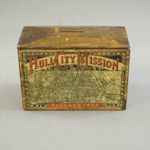
Map, Cartographic Curiosity, Collection Box, Hull City, England, Antique, c. 1904
-

Map, India, Cartographic Curiosity, Indus Basin Project, Rosewood with Brass Inlay, c. 1960s
$650 -

Map, Japan, Cartographic Curiosity, Japanese Military Aviation, Brass Engraved Tray, 1934
$975 -

Map, Long Island, Bathymetric, Aluminum Plaque, Art Deco
$475 -

Map, Michigan, Student’s Manuscript, Folk Art, Antique Drawing, 1854
$925 -
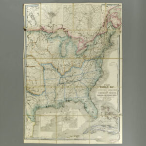
Map, Military, Civil War, United States, James Wyld, London, 1861
$3,800 -

Map, Military, Korean War, Pacific Stars and Stripes, Vintage Print, 1953
$550 -
![So Steht Der Krieg! [As The War Stands]](https://www.georgeglazer.com/wpmain/wp-content/uploads/2019/08/steht-der-krieg-map-front-300x300.jpg)
Map, Military, WWI, German War Map, Antique Print, Germany, 1915
-

Map, Military, WWI, Satirical Map of Europe, Antonio Soares, Antique Print, Portugal, c. 1916
-
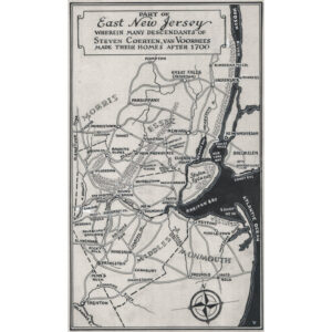
Map, New Jersey, Stephen Voorhies, Ink Drawing, Mid 20th C.
-

Map, New York City, Bradford Lyne 1728, Antique Print, New York, Colored, late 19th Century
$700 -
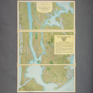
Map, New York City, Port of New York Aero View, C.P. Gray, Antique Print, 1912
$2,300 -

Map, Novelty, Gulf Stream, Atlantic Ocean, Navigation, Antique Print, Philadelphia, 1799
$950 -
![Norris' Map of the United States of America together with adjacent portions of the Dominion of Canada and the United States of Mexico [Zylo-Karta Games]](https://www.georgeglazer.com/wpmain/wp-content/uploads/2018/05/zylokarta1-300x300.jpg)
Map, Novelty, United States, Zylo-Karta Game, Cartographic Curiosity, Antique, New York, 1884
$1,200 -

Map, Pictorial, Fantasy, Marvelous Land of Oz, c. 1920s
-

Map, Rock Island Line Railroad, President’s Custom Boxed Set of 15 State Maps, c. 1922-33
$4,800 -

Map, Texas, Pictorial, Satirical, Humorous Illustrations, Vintage Print, Dallas, 1951
-

Map, United States, Pictorial, New Yorker’s Idea, Daniel Wallingford, Vintage Print, c. 1930
$450 -

Map, United States, Pictorial, New Yorker’s Idea, Daniel Wallingford, Vintage Print, c. 1930
$450 -

Map, United States, Pictorial, Nicknames of the States, Hill Hog Rings, Antique, Illinois, 1884
-

Map, World, Pictorial, View of the World, Phelps & Watson, Antique Print, New York, 1862
$3,500 -

Map, World, Specialty, Flight Routes, Japanese, Aviation, Vintage Print, 1930
-

Map, World, Specialty, Short Wave Radio, Philco Company, Vintage Poster, c. 1930s
-
![Isaac F. Pheils Map of the World with U. S. Supplement [Map Clock]](https://www.georgeglazer.com/wpmain/wp-content/uploads/2016/12/pheils-clock-map-300x300.jpg)
Map, World, Specialty, Time Clock, Polar Hour Circle Volvelle, Antique Print, 1901
-

Portrait, Exploration, La Salle, French Explorer, Louisiana Territory Map, Antique Print, 1937
$1,300 -

Reference Book, Antique Maps, Pictorial, You Are Here, Katharine Harmon, 2004
$30 -

View, Great Plains, Union Pacific Railroad, Antique Map, Chicago, 1890s