⊕ Click main image below to view enlargements and captions.
Map, Michigan, Student’s Manuscript, Folk Art, Antique Drawing, 1854
$925
C.D. LeBaron Michigan
American: March 14, 1854
Pencil and watercolor on paper watermarked “London Abraded”
Signed and dated lower left
15 x 12.25 inches overall
$925
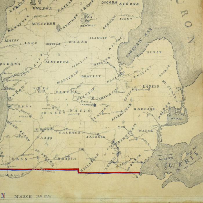
A rare folk art manuscript map of the State of Michigan, dated 1854, including most of Michigan’s Upper Peninsula except for the far western portion. The detailed hand-lettered map is drawn in pencil on paper with the southern state line, title and artist’s name highlighted in red and blue watercolor. Geography includes the Great Lakes, lakes and rivers, counties and major towns. Two railroad lines through the southern portion of the state are marked with dotted lines. The lengths in miles of each of the Great Lakes are noted. The map is signed and dated in the lower left and was apparently created by a student as a geography and drafting exercise.
Geography was an important subject in 19th century American classrooms. Creating a map was a common project for American students, generally of the United States, or a local state or county. Such maps were often executed in pen and ink or pencil, and highlighted with wash. This kind of project also was used to teach skills in art, drafting, penmanship, and calligraphy. Similarly, embroidered maps were also frequent school projects — generally for girls — as both geography and sewing exercises. The original source of the map presumably was a student’s school geography atlas. These were widely published and distributed to school children in the 19th century in inexpensive quarto editions.
Condition: Generally very good with the usual overall light toning, wear. Slightly greater oxidation at outer edges.