
19th century
Showing 391–429 of 699 results
-

Map, New York City, Central Park, Valentine’s Manual, Antique Print, 1860
$800 -

Map, New York City, Central Park, Visitor’s Guide Pocket Map, Antique Print, 1859
-

Map, New York City, City Hall, Anthony Imbert, Antique Print, c. 1825-35
$700 -

Map, New York City, David Burr, Wall Map, Antique Framed Print, 1832
-

Map, New York City, Joseph Shannon, Antique Print, 1868 (Sold)
-

Map, New York City, Lower Manhattan, Augustus Mitchell, Antique Print, c. 1846 -1859
-

Map, New York City, Lower Manhattan, Thomas Bradford, Antique 1846
$300 -

Map, New York City, Lower Manhattan, William Hooker, Antique Print, 1832
$850 -

Map, New York City, Metropolitan Area, Westchester, Fairfield County, 4 Antique Prints, Hyde, 1887
-

Map, New York City, Midtown and Lower Manhattan, Augustus Mitchell, Antique c. 1860 to 1867
-

Map, New York City, Plan by William Bridges, Antique Print, Isaac Riley, New York, 1807 (Sold)
-

Map, New York City, Promotional Advertising Broadside, Antique Wall Map, c. 1865
$2,900 -

Map, New York City, Ratzer Plan, Antique Print, J.H. Colton, New York, 1853 (Sold)
-

Map, New York City, The Great Metropolis, Antique, Taintor Brothers, New York, 1867
$1,250 -

Map, New York City, The Great Metropolis, Antique, Taintor Brothers, New York,1868 (Sold)
-

Map, New York City, Upper East Side, Upper West Side, Broadside Real Estate Plat, Antique1852
$1,250 -
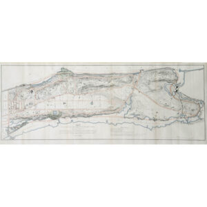
Map, New York City, Upper Manhattan, Antique Print, New York, c. 1868
-

Map, New York State, Bedford, F.W. Beers, Antique Print, 1867
$300 -

Map, New York State, Ensign, Bridgman & Fanning, Antique Illustrated Map, 1855
$3,500 -

Map, New York State, J.H. Eddy, Antique Wall Map, New York, 1818
$3,200 -

Map, New York State, Wall Map, Sherman & Smith, Ensign & Thayer, Antique Print, 1851
$2,725 -

Map, New York, Long Island, LIRR, Antique Print, 1907
$600 -

Map, North America, Tallis’s Illustrated Atlas, 1851 (Sold)
-

Map, North Pole, William Bauman, New York, Late 19th Century
$1,200 -
![Norris' Map of the United States of America together with adjacent portions of the Dominion of Canada and the United States of Mexico [Zylo-Karta Games]](https://www.georgeglazer.com/wpmain/wp-content/uploads/2018/05/zylokarta1-300x300.jpg)
Map, Novelty, United States, Zylo-Karta Game, Cartographic Curiosity, Antique, New York, 1884
$1,200 -

Map, Pennsylvania, Anthony Finley, Antique Wall Map, Philadelphia, 1829
$975 -

Map, Pennsylvania, Lower Dublin Township, 1810, Antique Manuscript Map (Sold)
-

Map, Pennsylvania, Pictorial, Ensign, Bridgeman and Fanning, Antique Print, New York, 1855
$3,500 -

Map, Pennsylvania, Pocket Map, Antique, Colton, New York, 1878
$325 -
![Carte Des Provinces Meridionales des Etats-Unis [Map of the Southern United States]](https://www.georgeglazer.com/wpmain/wp-content/uploads/2017/12/rochefoucauld-carte-etats-unis-300x300.jpg)
Map, Southeastern United States, Rochefoucauld-Liancourt, Antique Engraving, Paris, early 19th Century
$975 -

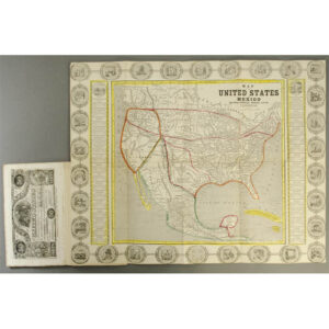
Map, United States, A.J. Johnson, Philadelphia: 3rd Quarter 19th Century
$450 -

Map, United States, Cartographic Curiosity, Cloth, Antique, Tuttle, Boston, c. 1840s (Sold)
-
Map, United States, Humphrey Phelps, Antique Print, New York, 1846
-

Map, United States, North America, Amerique Septentrionale, Vaugondy, Antique Print, Paris, 1750 (Sold)
-

Map, United States, Pictorial, Nicknames of the States, Hill Hog Rings, Antique, Illinois, 1884
-

Map, United States, Travelers, J. Calvin Smith, New York, 1846
$1,500 -

Map, Vermont, George White, Antique Print, c. 1850s
$950 -

Map, Vermont, Pocket, Anthony Finley, Antique Print, 1820s
$350 -

Map, Washington, D.C., Mitchell’s New General Atlas: c. 1867-1880s, Antique
$250