


Description
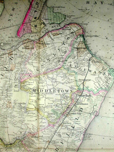
The key identifies symbols representing boulevards and prominent roads, country roads, poor roads, railroads, elevated roads, rapid transit roads, aqueducts and canals, and marshes & low lands. Cities and incorporated towns are shown colored by wards. Figures are given showing the depths of water and the names of some residences are indicated.
Issued as four folding maps, backed on linen in two separate covers, each housing two maps. The covers are labeled “North-West and South-West” and “North-East and South-East.”
Hyde & Company (later E. Belcher Hyde Map Company) was the main publisher of maps and atlases on Long Island from 1880 to 1920, which they issued in various formats, from folding maps to larger atlases. They produced detailed maps for the fire insurance industry that were updated on an annual basis based on surveys by Hyde employees. The degree of detail and specificity of these maps allowed the insurance companies to estimate the liability of certain properties because they showed every structure in an area, its building materials and size, its function, and other pertinent information about the street and surroundings. The company also published maps and atlases, including road maps, from the late 19th century and well into the 20th century, of Manhattan, Brooklyn, Queens and the New York Metropolitan area. Their major competitors in the publication of Long Island maps were F.W. Beers, G.W. Bromley & Co. and Chester Wolverton.
William Bracher was a German-born engraver who emigrated to the U.S., working in Philadelphia.
Condition: Generally very good with the usual light overall toning, wear, soft creases, and some minor separations at intersections of folds. The covers very good with little wear, mostly to spine.
Reference:
“Historical Maps and Atlases: Belcher Hyde and Sanborn Company Maps.” Queens Borough Public Library. http://www.queenslibrary.org/central/longisland/maps_bhyde.asp (11 August 2003).
Wright, Artis Q. “Navigating the Library’s New York City Maps.” New York Public Library. https://www.nypl.org/blog/2016/12/14/nypl-new-york-city-maps (3 September 2020).
Young, William, Ed. A Dictionary of American Artists, Sculptors and Engravers. Cambridge, Massachusetts: William Young and Co., 1968, p. 60.


