
Description
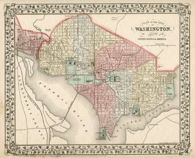
The plans shown are based on the original design of French engineer Pierre-Charles L’Enfant, commissioned by President George Washington in 1790. L’Enfant submitted his plan in August of 1791. The design was influenced by Baroque landscape architecture and the projection of a population of 800,000. The city plan consisted of the use of a square grid system scattered with radiating avenues resembling the spokes of a wheel that came together at significant focal points. L’Enfant was succeeded by Andrew Ellicott in the development of the nation’s capital.
Samuel Augustus Mitchell and his son and successor, S. Augustus Mitchell Jr., were successful Philadelphia-based map publishers. According to the map historian Walter W. Ristow, “[b]etween 1831 and 1890, general map and atlas publishing in the United States was dominated by the companies founded by S. Augustus Mitchell in Philadelphia and Joseph H. Colton in New York City.” Neither Mitchell nor Colton had formal training in geography or cartography; “[t]heir principal contributions to the success of their respective firms, therefore, was in administration, management, and distribution.” (Ristow, 303, 315).
Samuel Augustus Mitchell Sr. began his career as a teacher. He thought American geography books were not of sufficient quality, so he decided to publish better ones by starting his own business. He had no training in cartography; thus he purchased engravings from other cartographers and atlas publishers such as Anthony Finley and Henry Tanner. Mitchell hired Finley’s chief engraver, J.H. Young, to improve and update the plates to show changes in American geography, such as those that regularly occurred with the expansion of the American west. Mitchell was a shrewd marketer and distributor. In addition to providing updated maps, he made them more desirable by adding aesthetic elements such as decorative borders. He also adopted lithography rather than engraving which allowed for greater printings at lesser costs, though the maps continued to be hand-colored. S. Augustus Mitchell Jr. took over the business upon his father’s retirement in 1860, and continued the family tradition with prolific map and atlas publishing.
The Mitchell family’s famous annual atlas, the New Universal Atlas, was first published by Henry Tanner starting in 1836. Mitchell published it under his own name starting in 1846, and he continued publishing it until 1849. In 1850, the copyright to Mitchell’s atlas was first acquired by Thomas, Cowperthwait & Co., and then in 1856 by Charles DeSilver, both Philadelphia publishers. Thomas, Cowperthwait added five maps for their 1853 edition. DeSilver still owned the copyright in 1859, when another edition came out published by Cushings & Bailey, Baltimore, which added 23 more maps. In 1860, when S. Augustus Mitchell, Jr. succeeded his father, the Mitchells published the atlas again, and the name of the atlas was changed to the New General Atlas.
Full publication information: S. Augustus Mitchell, Jr., 31 South Sixth Street, Philadelphia
Condition: Generally very good with the usual light toning, wear, soiling, soft creases. Center fold as issued.
References:
David Rumsey Map Collection. 2003. http://www.davidrumsey.com/view.html (9 November 2006).
Dube, Ann Marie. “Endnotes: A Multitude of Amendments, Alterations and Additions.” Park Net, National Park Service. 17 January 2003. http://www.cr.nps.gov/history/online_books/dube/inde17.htm (10 April 2003).
Ristow, Walter. American Maps and Mapmakers. Detroit, Michigan: Wayne State University Press, 1985. pp. 303, 315.
“Today in History Archive: A Capital City.” Library of Congress. http://memory.loc.gov/ammem/today/jul16.html (10 April 2003).
“The City of Washington, D.C.” D.C. City Pages. 1996. http://dcpages.ari.net/Hwdc/wdc.html (10 April 2003).


