


Description
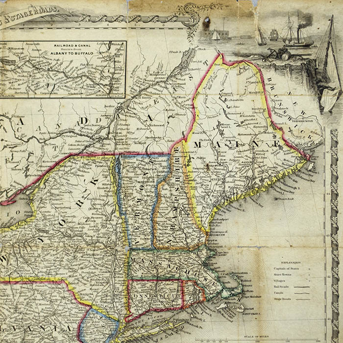
An inset map at the top shows rail and canal routes in Upstate New York between Albany and Buffalo. Other inset maps along the right side show New England and Northeast rail routes and the course of the Hudson River from New York City to Albany. The map captures the rapidly growing transportation network of roads, trains, and canals linking the East Coast with the Great Lakes region and other states east of the Mississippi. An inset “Map of Oregon, Northern California, Santa Fé &c.” reflects interest in these remote western regions among Americans. “California” includes current Nevada and Utah, “Oregon” includes the entire Pacific Northwest. These regions, the Upper Midwest, and areas west of the Mississippi are labeled with the names of the predominant Native American tribes.
Sherman & Smith was an American map publishing firm based in New York City from 1840 to 1853 It was a partnership between the engraver George E. Sherman (born 1810/11) and the surveyor, geographer, and engraver John Calvin Smith (1809-1890). They produced many maps and engravings for government publications, such as the official records of the 1838-1842 United States Exploring Expedition. They also produced maps for the Army Corps of Engineers and New York State Geological Survey, along with U.S. coastal surveys and railroad maps. Sherman worked as an engraver in New York from 1840 until at least 1860. Smith began working in New York in 1835. He was a charter member of the American Geographical Society. Sherman & Smith sometimes published as Stiles, Sherman & Smith in collaboration with the engraver Samuel Stiles (1796-1861). John Calvin Smith also worked with other cartographers and publishers including John Disturnell and J.H. Colton, and published maps under his own name.
Full Title: A New Map for Travelers Throughout the United States of America Showing the Railroads, Canals & Stage Roads, with the Distances
Condition: Generally very good with the usual overall light toning, wear, handling. Formerly a folding travelers map with folds as issued, now professionally flattened and backed with Japanese paper. With some remaining minor wear, discoloration, losses at folds and intersections. Margins short as issued. Original covers lacking.
References:
“A New Map for Travelers through the United States of America Showing the Railroads, Canals and Stage Roads, 1846.” World Digital Library. 28 October 2014. https://www.wdl.org/en/item/9559/ (5 October 2020).
Groce, George C. and Wallace, David H. The New-York Historical Society’s Dictionary of Artists in America 1564-1860. New Haven: Yale University Press, 1969. pp. 575-576, 588.
Peters, Harry T. America on Stone. U.S.: Doubleday, Doran, 1931. pp. 181, 325.