
Archive: Sold Maps & Views
Showing 40–78 of 113 results
-

Map, New York City, Brooklyn, Pocket Map, Matthew Dripps, Antique Print, 1869 (Sold)
-

Map, New York City, Casimir Goerck, Antique Manuscript Plat, 1796 (Sold)
-

Map, New York City, Ile de New York, Revolutionary War Plan, Antique Print, c. 1807 (Sold)
-

Map, New York City, Joseph Shannon, Antique Print, 1868 (Sold)
-

Map, New York City, Pictorial, Historical, National City Bank, Vintage Print, 1932 (Sold)
-

Map, New York City, Pictorial, Manhattan Depicting Bright Spots in that Dark Era, Prohibition, 1932 (Sold)
-

Map, New York City, Plan by William Bridges, Antique Print, Isaac Riley, New York, 1807 (Sold)
-

Map, New York City, Ratzer Plan, Antique Print, J.H. Colton, New York, 1853 (Sold)
-

Map, New York City, The Great Metropolis, Antique, Taintor Brothers, New York,1868 (Sold)
-

Map, North America, Tallis’s Illustrated Atlas, 1851 (Sold)
-

Map, Pennsylvania, Lower Dublin Township, 1810, Antique Manuscript Map (Sold)
-

Map, Rhode Island, Pictorial, Newport, Maritime, Vintage Print, c. 1940s (Sold)
-

Map, Scotland, Pictorial, Story Map of Scotland, Vintage Print, 1930s (Sold)
-

Map, Switzerland, Pictorial, Ernest Dudley Chase, Vintage Print, 1936 (Sold)
-

Map, Tryon, North Carolina, Pictorial, Dorothy Ellerbrook (Sold)
$1,150 -

Map, United Kingdom, Pictorial, British Isles, Ernest Dudley Chase, Vintage Print, 1935 (Sold)
-

Map, United States as Viewed by California, Pictorial, Ernest Dudley Chase, Vintage Print, 1940 (Sold)
-

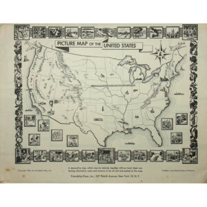
Map, United States, Cartographic Curiosity, Braille Relief, Relief Plastic, c. 1965-1985 (Sold)
-

Map, United States, Cartographic Curiosity, Cloth, Antique, Tuttle, Boston, c. 1840s (Sold)
-

Map, United States, North America, Amerique Septentrionale, Vaugondy, Antique Print, Paris, 1750 (Sold)
-
Map, United States, Pictorial, Louise Jefferson, Vintage Print, 1950 (Sold)
-

Map, United States, Pictorial, New Yorker’s Idea, Bostonian’s Idea, Wallingford, Pair, Vintage Prints, c. 1930s (Sold)
-

Map, United States, Pictorial, Our United States, Edward Everett Henry, Vintage Print, 1930 (Sold)
-

Map, United States, Pictorial, Philatelic, Ernest Dudley Chase, Vintage Print, 1959 (Sold)
-
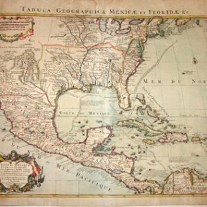
Map, United States, Southeast, Tabula Geographica, Covens & Mortier, Amsterdam, 1722 (Sold)
-

Map, Washington, D.C., Ellicott, Russell, Antique Print, London, 1795 (Sold)
-

Map, Washington, DC, Pictorial, Bird’s-eye Panorama, Oliver Whitwell Wilson, Vintage Print, 1949 (Sold)
-

Map, West Indies, De Laet: 1630, Antique (Sold)
-

Map, World, At One View, Antique Print, New York, c. 1852 (Sold)
-

Map, World, Cartographic Curiosity, Stained Glass, Czech, Early 20th C. (Sold)
-

Map, World, Double Hemisphere, Mappe-Monde, Covens & Mortier, Amsterdam, c. 1745 (Sold)
-

Map, World, Mercator’s Projection, Ensign Thayer, Wall Map, New York, 1851 (Sold)
-

Map, World, Mercator’s Projection, JH Colton, Antique, New York, 1856 (Sold)
-

Map, World, Pictorial, Edward Everett Henry, Vintage Print, 1928 (Sold)
-

Map, World, Pictorial, Graf Zeppelin, Radio Show, Chicago, 1929 (Sold)
-

Map, World, Pictorial, Postage Stamps, Ernest Dudley Chase, Vintage Print, c. 1947 (Sold)
-

Map, World, Pictorial, United in Peace, Ernest Dudley Chase, Vintage Print, c. 1945 (Sold)
-

Map, World, Pictorial, World War II Battle Strategy, Ernest Dudley Chase, Vintage Print, 1942 (Sold)
-

Map, World, Pictorial, World War II Battles, Ernest Dudley Chase, Vintage Print, 1942 (Sold)