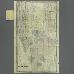
Description
The geographic information is detailed, showing streets and piers in the river, and dashed lines for major and minor railroads. Large buildings are shown as black silhouettes. Locations of churches are indicated by small crosses. Major parks and cemeteries are colored green; paths through them are shown and they are decorated with tiny symbols of trees. Marshes are indicated by a pictorial pattern. The East River shows detailed navigation information: locations of buoys and ferry routes, as well as numbers indicating depth soundings.
Brooklyn — currently one of five boroughs of New York City — was the third largest city in the United States in 1878. It narrowly voted to consolidate with New York City in 1898. The City of Brooklyn had evolved out of six distinct towns in Kings County, most developed during the Dutch colonial period: Brooklyn, Bushwick, New Utrecht, Gravesend, Flatbush, and Flatlands. This large pocket map provides a detailed view of the beginning of major growth of Brooklyn as a city in the early years following the end of the Civil War. Brooklyn had played a major role in supplying troops and materiel for the American Civil War. It had served a major role in building ships in the war, and this led the way for its continued industrial and commercial expansion thereafter.
Matthew Dripps (died 1896) was a New York map publisher. An Irish immigrant to America in 1843, he published a map of Trenton, New Jersey, in Philadelphia in 1849, then moved his business to New York in about 1850. According to Augustyn and Cohen, he was among the entrepreneurs who capitalized on a market for detailed urban maps, which were useful to insurance companies and other local businesses. He published two large wall maps of the northern and southern halves of Manhattan in 1851, each measuring about 3 x 6.5 feet. His company produced wall maps and folding pocket maps of portions of the New York City area regularly thereafter. It was listed in business directories until at least 1890. He also published maps of Newport, Rhode Island, and of the whole United States.
Full publication information: M. Dripps, 103 Fulton St. N.Y. Entered according to act of Congress, in the year 1863 by M. Dripps in the Clerks Office of the District Court for the Southern District of New York.
Condition: Generally very good with the usual overall light toning, wear, soft creases. Folds as issued, some with minor separations along the fold lines and minor openings at the fold intersections. Covers very good with light wear.Seller can have the map professionally flattened and backed with Japanese tissue for framing for an additional expense to the Purchaser of approximately $250.
References:
Ballon, Hilary. The Greatest Grid: The Master Plan of Manhattan, 1811-2011. New York: Museum of the City of New York and Columbia University Press, 2012. 76.
Cohen, Paul E. and Augustyn, Robert T. Manhattan in Maps: 1527-1995. New York: Rizzoli, 1997. pp. 124-127.
“Contributor: Dripps, M. (Matthew).” Library of Congress. https://www.loc.gov/search/?fa=contributor:dripps,+m.+%28matthew%29 (28 August 2020).
“Matthew Dripps.” Find a Grave. 2020. https://www.findagrave.com/memorial/64967915/matthew-dripps (28 August 2020).
Ristow, Walter W. American Maps and Mapmakers: Commercial Cartography in the Nineteenth Century. Detroit: Wayne State University Press, 1985. p. 257.