
Description
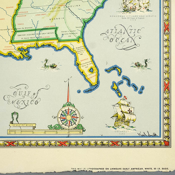
Across the top of the map are a series of five small captioned illustrations showing “The Development of Our Flag.” At the lower left is a decorative cartouche with title flanked by images of Washington on horseback and a Revolutionary War solider,. The cartouche is surmounted by an eagle in profile and a stars and stripes shield and listed below it is a timeline of “Important Historical Data Not Shown on Map.” Mexico and Canada are colored gray and left blank, except for a few notations on the Canadian portion, and both of their national seals are illustrated in color.
There were four maps in the original set produced by Linweave. The other maps covered the periods 1784 to 1844, including the War of 1812 and the Westward Expansion; 1845 to 1866, including the run-up to the Civil War and its immediate aftermath; and 1867 to 1959, including the two World Wars, the Korean War, the adoption of Alaska and Hawaii as states, and “later developments in transportation.” The offered map bears promotional text “Published by ‘Linweave’, producers of Quality Papers, with Envelopes to match,” and is imprinted lower right, just above a deckle edge, “This map is lithographed on Linweave Early American, White, 80 lb. basis.”
Karl Smith was a designer and illustrator of pictorial maps. His primary career was as an executive in the paper and graphic arts industries, but he drew maps as an avocation. Smith was also an active amateur historian who amassed a major collection on heraldry and genealogy and presented lectures on printing, paper, color, heraldry, and the life of Benjamin Franklin. In the 1930s and 1940s, the Speed Art Museum (then the J.B. Speed Art Museum) in Louisville, Kentucky, commissioned Karl Smith to make a series of pictorial maps of the states. In 1959 he created a series of four historical pictorial maps of the United States for Linweave Paper Company, showing the nation’s growth and development from the colonial era to the present. Over the course of his career he produced maps of North Carolina, Arkansas, Ohio, Mississippi, Illinois, Indiana, Kentucky, Florida, the Stratford Plantation in Virginia, and historical maps of the lives of Abraham Lincoln and Robert E. Lee.
Full publication information: Copyrighted 1959 by Linweave, Springfield, Mass.
Condition: Generally very good, recently professionally cleaned and deacidified with only light remaining toning and wear. Deckle edge lower margin as issued.
References:
“Growth and development of America in maps by Linweave.” Springfield, Massachusetts: Linweave Paper Company, 1959. Online at: David Rumsey Map Collection. https://www.davidrumsey.com/luna/servlet/detail/RUMSEY~8~1~290344~90061854:Text-Page–Growth-and-development-o?qvq=w4s:/who%2FSmith%2C%2BKarl;lc:RUMSEY~8~1&mi=4&trs=30 (16 April 2019).
Hornsby, Stephen J. Picturing America, The Golden Age of Pictorial Maps. Chicago: University of Chicago Press, 2017. pp. 166-67.
“Images by Smith, Karl.” David Rumsey Map Collection. https://www.davidrumsey.com/luna/servlet/view/all/who/Smith,+Karl (16 April 2019).