Pictorial Map, Cape Cod

Map, Massachusetts, Cape Cod, Pictorial, Clara Katrina Chase, Vintage Print, c. 1950s-1960s

Clara Katrina Chase
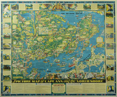
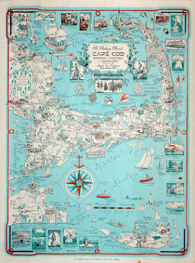
A Picture Chart of Cape Cod, Martha’s Vineyard and Nantucket
[Alternate title: The Pilgrim Map, Cape Cod, Martha’s Vineyard and Nantucket]
Atlantic Card Company, North Abington, Massachusetts:
Copyright 1949, 1956, later editions c. 1960-63
Medium size, 22.5 x 17.5 inches overall: Please inquire as to current availability.
Small size, 16.5 x 12.5 inches overall: $375

Pictorial map of the Cape Cod area, including Martha’s Vineyard, Nantucket, Falmouth, Hyannis, Plymouth, Provincetown, and Chatham. The map depicts bird’s-eye images of major sites and attractions, the Cape Cod Canal, highways, railroads, beaches, boats, seagulls, beachgoers, and lighthouses. Also featured are Plymouth Rock, the “Good Ship Mayflower,” and Martha’s Vineyard State Park. Inset illustrations of historic buildings and tourist attractions such as Brewster’s Old Windmill and “A Bit of Provincetown” decorate the upper, lower and right margins. Other decorative embellishments include a compass rose with a rope border surmounted by an anchor, and a cartouche flanked by pine needles, vines, and a codfish. Other decorative embellishments include a compass rose with a ropen border surmounted by an anchor, and a cartouche flanked by pine needles, vines, and a codfish. This map, first copyrighted 1949 and 1956, was printed in small, medium and large sizes, in various editions, with alternate titles. Editions showing “President Kennedy’s Summer Home” were apparently published c. 1960-63, or later.

Product Description Continues Below

Pictorial Map, Cape Ann and the North Shore

Map, Massachusetts, Cape Ann and the North Shore, Pictorial, Vintage Print, 1934 (Sold)

Errol W. Goff (1903-1974) (after)
A Picture Map of Cape Ann and the North Shore
Houghton Mifflin Co., Boston, Massachusetts: 1934
Color process print
28.5 x 34.25 inches, image
29 x 34.75 inches, overall

Detailed large color pictorial map of Cape Ann and the North Shore on Coastal Massachusetts. The area is rich in sites and landmark structures pertinent to American colonization and early history from the 17th century to 19th century, which are exhaustively illustrated and explained with captions. The area’s maritime heritage is also featured, including depictions of vessels from different eras in the Atlantic Ocean. The detailed cartography includes towns, beaches, islands, state highways and bodies of water. Settlement dates of towns and cities are noted. The principal map is titled “Essex County, Massachusetts,” and includes a numbered legend in the lower margin listing points of interest. The principal map also includes inset maps of Ipswich Town, Newbury, Rockport, Gloucester, and Salem and is surrounded by 22 vignette illustrations related to the area’s history and historic structures. At the top, a larger central illustration incorporates a clipper ship under a banner reading “Romance — History,” flanked by Pilgrims, 18th-century colonists in three-cornered hats, and 19th-century sailors and a woman and girl. A blue border is inscribed in block letters along the top and bottom edges: “This region was known as Wingaersheek to the Indians called Cape Tragabigzanda by Capt. John Smith then Cape Ann by Prince Charles in Honor of His Mother Anne of Denmark.” The left and right borders contain the names of Cape Ann towns: Danvers, Marblehead, Beverly, Hamilton, Wenham, Newburyport, Rockport, Gloucester, Essex, Manchester, Ipswich, Salem and Peabody.

Product description continues below.

Colortext Story Map of Scotland

Map, Scotland, Pictorial, Story Map of Scotland, Vintage Print, 1930s (Sold)

Story Map of Scotland
Colortext Publications, Inc., Chicago: 1935-36
Color process print
15.5 x 12 inches, border
17 x 13.5 inches, overall

A detailed and colorful pictorial map of Scotland, filled with drawings of historic sites, incidents and portraits of important Scottish men and women, including explanatory captions. Insofar as there is so much historical information, geography is kept simple to major rivers and other bodies of water, counties, cities and towns. There are ships in the oceans — both historic vessels and others left uncaptioned — and numerous depictions of wild and domesticated animals on the mainland and fish in the sea. A few sites on the southern border with England are also included, with a compass rose in the lower right corner and a coat of arms lower left. The map is surrounded by an elaborate border design of Scottish tartans from different clans. The cartouche is surrounded by a border design of thistles, which are symbols of Scotland, surmounted by a coat of arms.

Product description continues below.

Story Map of Ireland

Map, Ireland, Story Map of Ireland, Vintage Print, 1930s

Story Map of Ireland
Colortext Publications, Inc., Chicago: 1936
Color process print
17 x 13.5 inches
$450

A detailed and colorful pictorial map of Ireland, filled with drawings of historic sites, incidents and portraits of important Irish men and women, including explanatory captions. Insofar as there is so much historical information, geography is kept simple to major rivers and other bodies of water, counties, cities and towns. There are ships in the oceans — both historic vessels and others left uncaptioned — and whimsical touches on the mainland such as a leprechaun. The seas also contain groups of portraits: “Dublin’s Sons,” “Irish Patriots,” and “Modern Bards.” In the lower right corner, another such group, “Erin’s Heroes,” are blessed by a Roman Catholic bishop standing before a Gothic window. The map is surrounded by an intricate border design and title decorations, which a caption in the lower right margin explains were adapted from two famous Celtic illuminated manuscripts, the Book of Kells (6th century) and the Book of Macdurnan (10th century).

Product description continues below.

Story Map of France

Map, France, Pictorial, Story Map of France, Vintage Print, 1936

A. Walker and W.E. Vogelear (after)
Story Map of France

Colortext Publications, Inc., Chicago: 1936
Color process print
17 x 13.5 inches
$300

A detailed and colorful pictorial map of France, filled with drawings of historic sites, incidents and portraits of important French men and women, including explanatory captions. Insofar as there is so much historical information, geography is kept simple, showing major rivers and other bodies of water, counties, cities and towns. There are ships in the oceans — both historic vessels and others left uncaptioned — and whimsical beings such as the sea monster in the Atlantic Ocean and the merman holding a staff topped by a fleur-de-lis in the compass rose. Other interesting features include the “German farthest advance” in World War I and a drawing of prehistoric cave paintings in the Dordogne region.

Product description continues below.

You Are Here book cover

Reference Book, Antique Maps, Pictorial, You Are Here, Katharine Harmon, 2004

Katharine Harmon
You Are Here
New York: Princeton Architectural Press, 2004
191 pp.

Please inquire as to current availability of signed books for $30

A wide-ranging collection of superbly inventive maps beyond the boundaries of geography or convention. These are charts of places you’re not expected to find, but a voyage you take in your mind: including maps of imaginary places or concepts, maps by artists, and pictorial maps of actual places. With over 100 maps from artists, cartographers, and explorers, You Are Here gives the reader a fascinating view of worlds, both real and imaginary.

Product description continues below.