Description
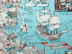
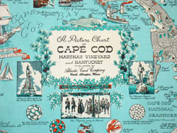
The smaller edition, titled A Picture Chart of Cape Cod, Martha’s Vineyard and Nantucket, has a printed credit “designed and drawn by Clara K. Chase.” Clara was the third wife of Ernest Dudley Chase, a prolific maker of pictorial maps during the mid 20th century, some of which were published by Trina Publishing or the Atlantic Card Company in Massachusetts, where the Chases lived. The Harvard Map Collection has the same map of Cape Cod with Ernest Dudley Chase’s manuscript signature, however, their copy was published by Trina Publishing with no copyright and no mention of Clara. The only change appears to be Clara’s addition of the words, “Cape Cod National Seashore.” Based on the description of the Plymouth Plantation in the upper left, the Harvard curators have concluded that Ernest’s original map dates from after 1948 and is probably c. 1950, while Clara’s version probably was issued between 1956 and 1961.
Mysteries remain about Clara’s role in Ernest’s pictorial mapmaking — whether she took over updating and publishing them in his old age, which would account for this Cape Cod map being issued in her name. That’s not the only mystery about the couple that will probably never be explained; in Ernest’s map of New York there is a small figure in a pond, labeled upside down in shadowy letters “Clara Katrina Holland.” They would be married some 20 years later.
Condition: Generally very good with the usual overall light toning, wear, soft creases.
Reference:
Cobb, David. “Re: Ernest Dudley Chase and Clara K. Chase.” E-mails dated 29 August 2005.