Europe, A Pictorial Map

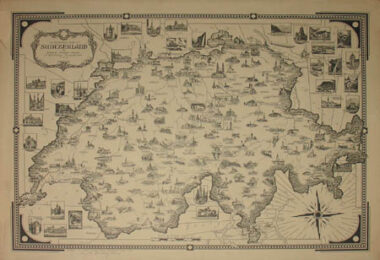
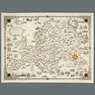
Map, Europe, Pictorial, Ernest Dudley Chase, Vintage Print, 1938 (Sold)

Ernest Dudley Chase (1878-1966)
Europe
Ernest Dudley Chase, Winchester, Massachusetts: 1938
Color process print
Signed in pencil lower left
17.25 x 23.25 inches ruled border
18.75 x 24.5 inches overall

Pictorial map of Europe, from Iceland and Spain in the west, to the Caspian Sea and Ural Mountains in the east. It is filled with illustrations of well known buildings, landmarks and historic sites, native animals, and local people engaged in activities such as farming. Geography is detailed but simple: national boundaries, lakes, mountain ranges drawn in aerial perspective, and numerous cities are indicated. Surrounding the land portion of the map are seas with rhumb lines converging on a compass rose, illustrations of ships from different eras, and many inset illustrations of important buildings such as Greek and Roman ruins and cathedral, all within a decorative Art Deco border. The Harvard University Map Collection owns an example of this map.

Product description continues below.

A Pictorial Map of Boston [Fairfield & Ellis Insurance Version]

Map, Boston, Pictorial, Insurance Version, Ernest Dudley Chase, Vintage Print, 1938 (Sold)

Ernest Dudley Chase (1878-1966)
A Pictorial Map of Boston
[Fairfield & Ellis Insurance Version]
Ernest Dudley Chase, Winchester, Massachusetts: 1938
Color process print
Not signed
17.25 x 23.25 inches, ruled border
19 x 25 inches, overall

Pictorial map of the city of Boston and vicinity, filled with drawings of buildings, landmarks and historic sites, many related to Boston’s important role in Colonial history. There are several larger inset illustrations of buildings such as the Masonic Temple and Simmons College. Geographical features include streets, railroads, piers, cemeteries, lowlands, and the route of Paul Revere’s ride. The map is the same as the one Chase published the same year with additional color as Boston (Massachusetts) and Vicinity: A Pictorial Map, with the exception of the cartouche which has different title information and illustrations and replaces the circular seal of the City of Boston with that of Fairfield & Ellis Insurance. As such it was apparently custom made as a promotional map for this insurance company. See the general Chase Boston map on our website.

Product description continues below.

Ernest Dudley Chase, A Pictorial Map of the British Isles

Map, United Kingdom, Pictorial, British Isles, Ernest Dudley Chase, Vintage Color Print, 1935

Ernest Dudley Chase (1878-1966)
A Pictorial Map of the British Isles
Ernest Dudley Chase, Winchester, Massachusetts: c. 1935
Color process print
17 x 23.25 inches, border
19.25 x 24.5 inches, overall
$1,225

Pictorial map of the British Isles issued in full printed color. Geography is simple: rivers and lakes; counties; and cities and towns, many of them accompanied by a small illustration of an iconic local landmark building to illustrate the whole. As is typical for Chase, within the map are a very large additional number of detailed illustration of landmarks and historic sites. In addition, the map is decorated with numerous inset illustrations of scenic places and buildings within rectangles or shield shapes in the waters, making full use of all otherwise blank space on the map. In the lower center, a compass rose radiates rhumb lines through the English Channel and Irish Sea; ships from different eras sail the oceans. The decorative border features elaborate British Gothic designs at the corners. The map is copyrighted 1935 in the lower left border. A more commonly encountered uncolored version was also copyrighted by Chase in in 1935. See that version on our website. Other examples of color printed versions of this map are known curiously with the copyright date omitted, including one in the Rumsey Collection.

Product description continues below.

Ernest Chase, World Wonders, A Pictorial Map

Map, World, Pictorial, World Wonders, Ernest Dudley Chase, Vintage Print, 1939

Ernest Dudley Chase (1878-1966)
World Wonders, A Pictorial Map
Ernest Dudley Chase, Winchester, Massachusetts: 1939
Color process print
17.5 x 23.5 inches, ruled border
19 x 25 inches, overall
$1,100

Pictorial map illustrating wonders of the world, including engineering, architectural and artistic achievements of mankind through the ages, as well as marvels of nature. Included are the Statue of Liberty, Empire State Building, Mayan temples, Egyptian Sphinx, Great Wall of China, Kremlin, Stonehenge, Hindenburg, and the Mona Lisa. Representing natural marvels are mountains and national parks such as Yellowstone, as well as animals such as the kangaroo, rhinoceros, buffalo and grizzly bear. Numerous inset illustrations with brief descriptions surround the map, including the “Seven Wonders” of the ancient world. The map is executed on Mercator’s projection with a decorative cartouche. It is printed in black and pale orange on cream colored paper, highlighted with a colorful compass rose in red and yellow. The border has ornate Art Deco corners. The Harvard University Map Collection also owns an example of this map, with continents colored yellow, oceans colored blue, and red accents in the cartouche, the border and some illustrations. Harvard’s copy appears in the book You Are Here by Katharine Harmon.

Product description continues below.

Ernest Dudley Chase, The Victory War Map

Map, World, Pictorial, World War II Battle Strategy, Ernest Dudley Chase, Vintage Print, 1942 (Sold)

Ernest Dudley Chase (1878-1966) (after)
The Victory War Map
Ernest Dudley Chase, Winchester, Massachusetts: 1942
Signed in pencil lower left
Color-process print
15.75 x 23 inches, overall

World War II-era map focusing on strategic transportation routes. Railroads and roads are indicated, with red dots for naval bases. The map includes all of Europe, as well as North Africa and Asia as far east as Calcutta. National boundaries and major cities are labeled, as are colonial territories in Africa, and rivers are indicated. The borders are decorated with the insignia of the U.S. Army, Navy and Marines. Chase made at least one other related map, Total War Battle Map (1942), which included the entire world and is also on our website. The Harvard University Map Collection also owns examples of this map.

Product description continues below.

Ernest Dudley Chase, Total War Battle Map

Map, World, Pictorial, World War II Battles, Ernest Dudley Chase, Vintage Print, 1942 (Sold)

Ernest Dudley Chase (1878-1966) (after)
Total War Battle Map
Ernest Dudley Chase, Winchester, Massachusetts: 1942
Color-process print
Signed in pencil lower left
15.75 x 36.5 inches, overall

A patriotic World War II pictorial battle map of the world on Mercator’s projection, subtitled: “Certain Victory Will be Ours!” Published during the first year of U.S. entry into the war, the map orients the American viewer with numerous legends noting the distances between locations in the U.S. and theaters of the war, such as San Francisco to Manila. The legend contains symbols for British Possessions, joint British and U.S. possessions, U.S. possessions, Japanese, French, and Dutch possessions, pre-war boundaries, naval bases and railroads. Japanese- and German-occupied or controlled areas are shown in black. Inset pictures show U.S. weapons: coast artillery, mobile field gun, new anti-aircraft gun mounts by Westinghouse, a Yank Tank, and a Flying Fortress. Small illustrations of battleships and airplanes are shown in and above the oceans. The letter V peeks out from behind the cartouche and is worked into the design of the border, as explained in the inset caption: “A Battle Map, to set the stage For ‘total war’ on land and sea; And, in the border, just a hint — A prayer for total Victory!” Chase made at least one other related map, The Victory War Map (1942), which focused on the European theater, and is also on our website. The Harvard University Map Collection also owns copies of both maps.

Product description continues below.

Ernest Dudley Chase, A Pictorial Map of Switzerland

Map, Switzerland, Pictorial, Ernest Dudley Chase, Vintage Print, 1936 (Sold)

Ernest Dudley Chase (1878-1966) (after)
A Pictorial Map of Switzerland
Ernest Dudley Chase, Winchester, Massachusetts: 1936
Signed lower left in pencil: “Ernest Dudley Chase”
Black-and-white print
17 x 23.25 inches, border
18.75 x 24.75 inches, overall

Pictorial map of Switzerland, filled with drawings of landmarks and historic sites. Geography is simple: rivers and lakes; cities and towns, many of them accompanied by a small illustration of a landmark building; and mountains and glaciers, drawn in perspective. Surrounding the nation’s borders are rhumb lines converging on a compass rose; there are also numerous inset illustrations of scenic places, buildings and bridges. The map is enclosed within a simple Art Deco border accented with Swiss crosses. The Harvard University Map Collection owns an example of this map.

Product description continues below.

Ernest Dudley Chase, A Pictorial Map of the British Isles

Map, United Kingdom, Pictorial, British Isles, Ernest Dudley Chase, Vintage Print, 1935 (Sold)

Ernest Dudley Chase (1878-1966)
A Pictorial Map of the British Isles
Ernest Dudley Chase, Winchester, Massachusetts: 1935
Signed lower left in pencil: Ernest Dudley Chase
Black-and-white print
17 x 23.25 inches, border
18.75 x 24.75 inches, overall

Pictorial map of the British Isles, filled with drawings of landmarks and historic sites. Geography is simple: rivers and lakes; counties; and cities and towns, many of them accompanied by a small illustration of a landmark building. In the lower center, a compass rose radiates rhumb lines through the English Channel and Irish Sea; ships from different eras sail the oceans. Numerous inset illustrations of scenic places and buildings set within rectangles or shield shapes surround the map. The decorative border features elaborate Gothic designs at the corners. The Harvard University Map Collection owns an example of this map. A few years later, Chase published a color version of the map, which can be viewed on our website.

Product description continues below.

Ernest Dudley Chase, The Pictorial Map, A World of Stamps

Map, World, Pictorial, Postage Stamps, Ernest Dudley Chase, Vintage Print, c. 1947 (Sold)

Ernest Dudley Chase (1878-1966)
The Pictorial Map, A World of Stamps
Ernest Dudley Chase, Winchester, Massachusetts: c. 1947
Sidney C. Trager, West Haven, Connecticut (distributor)
Signed lower left in pencil: Ernest Dudley Chase
Sepia print with colored highlights
21.5 x 34 inches, overall

Pictorial world map featuring reproductions of postage stamps, most of which are placed on or near the corresponding locales featured on the stamp. The rest are depicted around the map, with a letter and number corresponding to their location according to a key in the border, which in turn is cleverly drawn to resemble the perforated edge of a stamp. Geography is simple and follows the perforated border theme: national boundaries are noted with dotted lines, and the equator is indicated with a row of large white circles. Scattered throughout are brief inscriptions noting major events in the progress of postal delivery, as well as larger inset panels. The latter includes “Some Firsts” in mail history and the story of “The Famous One-Penny Black.” A red-highlighted compass rose, lower right, has four portraits taken from stamps: “Pasteur – Europe,” “Stanley – Africa,” “Washington – No. America,” and “Bolivar – So. America,” all surrounding a picture of the “World’s Rarest Stamp,” a British Guiana one-cent magenta from 1856 with only “1 Known Copy.” The cartouche is decorated with different modes of transportation for delivering mail and credits three researchers as Chase’s collaborators. The Harvard University Map Collection owns a copy of this map that they have tentatively dated 1947. They also have a related map featuring only U.S. stamps called The Pictorial Map, Stamps of America, published in 1947.

Product description continues below.

Ernest Dudley Chase, Mercator Map of the World United: A Pictorial History of Transport and Communications and Paths to Permanent Peace

Map, World, Pictorial, United in Peace, Ernest Dudley Chase, Vintage Print, c. 1945 (Sold)

Ernest Dudley Chase (1878-1966) (after)
Mercator Map of the World United: A Pictorial History of Transport and Communications and Paths to Permanent Peace
Oliver K. Whiting, London and Ernest Dudley Chase, Winchester, Massachusetts: c. 1945
Color photo-process print
15 x 36 inches, overall

A pictorial map with a hopeful message of the world united in peace, created as World War II was drawing to a close. It bears an optimistic and humanistic message of social progress through technological advancement. Historic milestones in transportation and communications history are illustrated throughout. The legend surrounding the cartouche includes symbols for “organizations already at work on an international basis” and modes of travel and communication. These include religion; travel by land, sea and air; international mail, telephone, and telegraph; radio; The Red Cross; health organizations; drug control; standards of measurements; and “the great international businesses.” Messages of peace abound, including a drawing, center top, of flags of different nations with a rainbow and the slogan “Bound by a code of international friendship, law and order, united we stand — divided we fall.” In addition to the more historically oriented illustrations are allegorical drawings such as one of several men on a globe-form sailboat emblazoned “World Unity,” with the caption “We are all in the same boat.” The artist also illustrates ideas for new technologies such as a missile captioned “Rocket Mail of the future.” The map is executed on Mercator’s projection with a decorative cartouche, the border with ornate corners decorated with cornucopias, one in the traditional manner overflowing with fruit and vegetables, the other overflowing with machine parts.

Product description continues below.