Click main image below to view enlargements and captions.

Map, Massachusetts, Cape Ann and the North Shore, Pictorial, Vintage Print, 1934 (Sold)

This item is sold. It has been placed here in our online archives as a service for researchers and collectors.

To find similar items in stock, browse or search our currently available items from our menu.

• See our guidelines for the use of images.
Contact the gallery with purchasing and ordering inquiries, or to offer items for sale.

Errol W. Goff (1903-1974) (after)
A Picture Map of Cape Ann and the North Shore
Houghton Mifflin Co., Boston, Massachusetts: 1934
Color process print
28.5 x 34.25 inches, image
29 x 34.75 inches, overall

Detailed large color pictorial map of Cape Ann and the North Shore on Coastal Massachusetts. The area is rich in sites and landmark structures pertinent to American colonization and early history from the 17th century to 19th century, which are exhaustively illustrated and explained with captions. The area’s maritime heritage is also featured, including depictions of vessels from different eras in the Atlantic Ocean. The detailed cartography includes towns, beaches, islands, state highways and bodies of water. Settlement dates of towns and cities are noted. The principal map is titled “Essex County, Massachusetts,” and includes a numbered legend in the lower margin listing points of interest. The principal map also includes inset maps of Ipswich Town, Newbury, Rockport, Gloucester, and Salem and is surrounded by 22 vignette illustrations related to the area’s history and historic structures. At the top, a larger central illustration incorporates a clipper ship under a banner reading “Romance — History,” flanked by Pilgrims, 18th-century colonists in three-cornered hats, and 19th-century sailors and a woman and girl. A blue border is inscribed in block letters along the top and bottom edges: “This region was known as Wingaersheek to the Indians called Cape Tragabigzanda by Capt. John Smith then Cape Ann by Prince Charles in Honor of His Mother Anne of Denmark.” The left and right borders contain the names of Cape Ann towns: Danvers, Marblehead, Beverly, Hamilton, Wenham, Newburyport, Rockport, Gloucester, Essex, Manchester, Ipswich, Salem and Peabody.

Product description continues below.

Description

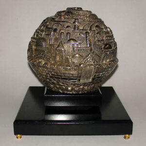
Errol W. Goff was a designer in Massachusetts. Little is known about him. He designed one pictorial map, of Cape Ann, Massachusetts, for Houghton Mifflin in 1934, and received a patent on a design for an ornamental clock in 1930, which he assigned to Warren Telechron Company of Maine. At the time the patent was recorded, he was living in Everett, Massachusetts. A genealogical web site states that he was born in 1903 in Lowell, Massachusetts, and died in 1974 in Hancock, New Hampshire.

Houghton Mifflin, now known as Houghton Mifflin Harcourt, is a venerable Boston publishing firm founded in the 19th century. In 1880, it merged with Ticknor and Fields and became known as Houghton, Mifflin and Company. By the end of the 1880s it established an educational department, which became a major part of the business. By 1921, it was the fourth-largest educational publisher in the United States. The firm published several pictorial maps by various designers between 1926 and 1934, including Cape Ann; Concord, Massachusetts; Philadelphia; Boston; Washington, D.C.; Chicago; as well as a world map designed by Ernest Dudley Chase in 1931.

References:

“Errol W. Goff.” Ancestry.com. 2009. http://familytreemaker.genealogy.com/users/c/a/r/Michael-T-Carroll/WEBSITE-0001/UHP-1260.html (22 January 2015).

“E.W. Goff. Clock or the Like.” U.S. Patent Office. 4 November 1930. Online at: http://patentimages.storage.googleapis.com/pdfs/USD82424.pdf (22 January 2015).

“Houghton Mifflin Harcourt.” Wikipedia. 18 November 2014. http://en.wikipedia.org/wiki/Houghton_Mifflin_Harcourt (22 January 2015).

Additional information

Century

20th Century