


Description
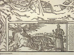
As is often the case with 16th and 17th century maps, this map has a complicated publication history. According to Ancient Maps of Jerusalem, a web site produced by the Jewish National and University Library and the Hebrew University of Jerusalem, the map is an exact copy of Braun and Hogenberg’s plan of Jerusalem (from Civitates… Theatrum des cites du monde, Brussels, 1575. Vol. I, No. 53.). Braun and Hogenberg in turn had copied the view on the right from one published a few years earlier by Gerard de Jode (1509-1591) in Novae Urbis Hierosolymitanae topographica in Antwerp (1571?). The de Jode map bears an inscription stating that it is drawn after a map by Peter Laicstain and published in Germany in 1570 (no known copies of which exist today). Examples of Belleforest’s, Braun and Hogenberg’s, and de Jode’s versions of this map may be found on the Ancient Maps of Jerusalem web site (see References below). The web site also notes that pre-19th century renderings of Jerusalem tended to be more artistic productions than geographically accurate ones, combining scenes and locations from different historical periods and incorporating biblical concepts associated with the sites depicted. Belleforest’s map is typical of its era in these respects.
François de Belleforest typified the “Renaissance man” – a prolific French author on a variety of subjects, as well as a poet and translator; in all he produced over 50 volumes including his translations. Born into a poor family, he eventually made his way to Paris where he met other young writers. He wrote on cosmography, morals, literature and history, authored the first French pastoral novel, La Pyrénée (1571), and from 1568 served as historiographer to the king. He translated works by German, Italian, Latin and Greek authors into French, including a renowned translation and adaptation of tragic tales by the Italian writer Matteo Bandello, published in seven volumes from 1564-82. One of those stories served as William Shakespeare’s source for Hamlet.
Georg Braun (1541-1622) and Frans Hogenberg (1535-1590) were among a flourishing group of cartographers based in Cologne, Germany, in the late 16th century, known for their major work Civitates Orbis Terrarum (1572-1617). The set usually was composed of six volumes, containing about 530 maps, mainly of cities in Europe, as well as some in Britain and on other continents. The plates comprise the first general collection devoted solely to topographical views. Many were the earliest engraved views of these towns. The inclusion of rural scenes, transportation routes and buildings remain an important record of the period. According to map scholar R.V. Tooley, the Braun & Hogenberg series “forms a wonderful picture book of Europe in the 16th century.”
Georg Braun was the editor of Civitates Orbis Terrarum, and Frans Hogenberg the chief engraver. They based their views mostly on existing maps. A large part of their work derived from Theatrum Orbis Terrarum, published in 1570 by the Antwerp cartographer Abraham Ortelius. This work was considered the first modern published atlas. Indeed, Theatrum Orbis Terrarum was in many respects the model for the Civitates, with similarities in titles, as well as the formats, layouts and order of the plates. The accompanying texts were in many cases also based on Ortelius’ work, as Braun indicated in the preface to the first part of the 1572 edition. Braun and Hogenberg also utilized drawings by other artists, notably the Antwerp artist Joris Hoefnagel (1542-1600), who had traveled through most of Western Europe.
Titles as follows:
Description de la Cité de Ierusalem, telle qu’elle fut du teps q nostre Sauveur viuoit au mode. [Description of the City of Jersualem, as it was in the times in which our Savior lived.]
Nouvelle description de la Cité de Ierusalem, telle qu’a present elle est figurée, & assise. [New description of the City of Jersualem, as it looks at the present time and place.]
Condition: Generally very good with the usual light overall light toning and wear. Center vertical fold, as issued.
References:
“Belleforest, François de… Ierusalem.” Ancient Maps of Jerusalem: The Jewish National and University Library and the Hebrew University of Jerusalem. http://maps-of-jerusalem.huji.ac.il/html/jer103.htm (28 October 2005).
“François de Belleforest.” Wikipedia. 23 September 2005. http://en.wikipedia.org/wiki/Fran%C3%A7ois_de_Belleforest (28 October 2005).
“Jode, Gerard de…Novae Urbis Hierosolymitanae…” Ancient Maps of Jerusalem: The Jewish National and University Library and the Hebrew University of Jerusalem. http://jnul.huji.ac.il/dl/maps/jer/html/jer009.htm (28 October 2005).
“Hogenberg, Franz…Hierosolyma…” Ancient Maps of Jerusalem: The Jewish National and University Library and the Hebrew University of Jerusalem http://jnul.huji.ac.il/dl/maps/jer/html/jer010.htm (28 October 2005).
“The Story of the Maps.” Ancient Maps of Jerusalem: The Jewish National and University Library and the Hebrew University of Jerusalem. http://jnul.huji.ac.il/dl/maps/jer/html/story.html (28 October 2005).


