Description


$700
Claude Martinez
Shelter Island and Parts Adjacent
American: 1962
Gouache and colored pencil on illustration board
Signed and dated lower right “Claude Martinez MCMLXII”
10.25 x 14.25 inches, image to ruled border
12 x 16 inches, overall
$700
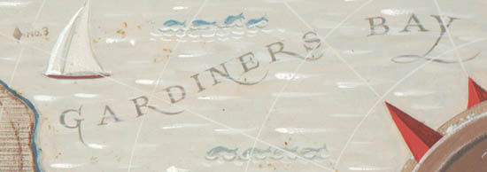
Original painted map of Shelter Island, located off the eastern end of Long Island in Suffolk County, New York. It includes the surrounding waters of Shelter Island Sound and Gardiners Bay, and the opposite shoreline of surrounding portions of Long Island. The map has simple cartography, showing harbors, coves and roads. A few land areas are labeled: Mashomack [Preserve], Shelter Island Heights, West Rock Point, Jennings Point, Cedar Point and Greenport. The roads are unlabeled with Rte. 114 in red and the rest in brown. Buoys are indicated by red squares and gray diamonds and labeled with their number; docks are indicated by anchors; and a red and white beach umbrella indicates the beach.
The cartouche is a round compass rose having the map title beneath a seascape vignette enclosed by a circle surrounded by triangular red compass points issuing white rhumb lines, and with a trident-form pointer. A peg-legged mariner looks through a spyglass at the island from the shore near Greenport. Small illustrations of boats and dolphins decorate the waters. The map is mainly executed in shades of brown, with edges of the land masses are shaded blue and white for a low relief effect. The waters are colored a lighter shade of brown, with white brushstrokes adding texture. The map is surrounded by a hatched border in brown and tan.
Condition: Generally very good with the usual overall light toning, handling, wear. Very minor occasional flaking of paint.