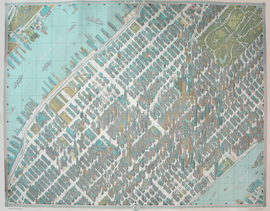


Description
An example of this map owned by George Glazer Gallery was included in The Greatest Grid, an exhibition at the Museum of the City of New York (December 2011 through June 2012) of maps documenting the development of the grid system of mapping Manhattan. It is also illustrated and described in the book accompanying the exhibition. According to the exhibition wall label this map “reveals the diversity of structures on Manhattan’s grid.” The book further notes:
[The rendering] highlights how the three-dimensional grid of the city is formed from individual buildings. The view demonstrates that the integrity of each rectangular block depends on the buildings that stand at its edge, and shows how the Midtown skyscrapers maximize that edge vertically as well as horizontally on the lot surface.
Read more about The Greatest Grid exhibition and book, or order the book here.
Hermann Bollmann was a German illustrator, graphic designer and cartographer. In the late 1940s he started producing pictorial maps as a way of depicting German cities after the bombing campaigns of World War II. Popular during the 18th and 19th centuries, the genre of the hand-drawn bird’s-eye city map had virtually disappeared with the advent of aerial photography, but Bollmann revived it with great success due to his innovative methods combining photographic documentation with a sense of design in order to make highly detailed yet readable cityscapes. Most of his maps were produced from the 1950s through 1970s.
Full publication information: New York Pictorial Map Copyright Pictorial Maps, Inc. No. 40. Created by Hermann Bollmann for Pictorial Maps, Inc. 97 Warren Street, New York City. Litho by Barnes Press, Inc.
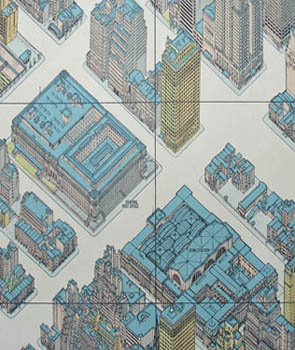
Details shown in pictures above include:
Detail of Rockefeller Center, the CBS Building, The New York Hilton, Sperry Rand, Equitable Life, and the Museum of Modern Art, as well as several popular restaurants.
Detail of the Pan Am Building — now the MetLife Building, the Chrysler Building and Grand Central Station.
Detail of the Empire State Building, Herald Square and the department stores Macy’s, Gimbels and B. Altman & Co. The Milliken Building, in the upper right corner, was demolished in 2009.
Detail of Times Square.
Detail of the United Nations Headquarters.
Detail of the General Post Office and Penn Station.
Condition: Most examples we have are folded as issued and in fine condition. Please inquire as to current availability and condition.
References:
Ballon, Hilary, ed. The Greatest Grid: The Master Plan of Manhattan 1811-2011. New York: Museum of the City of New York and Columbia University Press, 2012. Item 177. pp. 179-180.
Cohen, Paul E. and Augustyn, Robert T. Manhattan in Maps: 1527-1995. New York: Rizzoli, 1997. pp. 152-153.