Click main image below to view enlargements and captions.

Map, France, Regional, Blaeu, Dutch Antique Print, 17th Century

$250

Willem Janszoon Blaeu (1571-1638) / Joan Blaeu (1596-1673)
Les Souverainetez de Sedan et de Raucourt et la prevosté de Doncheri.
and
Descriptio Veromanduorum Auctore Ioanne Suthonio. Gallice Vermandois./ Gouvernement de la Cappelle par P. petit Bourbon.
Amsterdam: Mid 17th Century
Hand-colored engravings
15.25 x 20 inches, average approximate plate mark
19.75 x 24 inches, average approximate overall
$250 each

To view other works by the Blaeu family of cartographers, including maps and city views, and plates from Joan Blaeu’s three town-books of Italy, search our site.

Two early Dutch maps of towns, cities and regions in France. The title of Les Souverainetez de Sedan translates as “the Sovereignty of Sedan and of Raucourt and the Provostship of Doncheri.” The area depicted is Northern France near the border with Belgium, including the Meuse River and the principalities of Sedan and Raucourt, now in the Ardennes department of France. Descriptio Veromanduorum… translates as “Description of Vermandois by Johann Suthonio. Gallic Vermandois./ Government of La Cappelle by P. petit Bourbon,” and consists of two maps printed on one sheet, showing regions of France north of Paris and featuring the areas along the Oise River, including La Cappelle, Laon and Guise.

Product Description Continues Below

Description

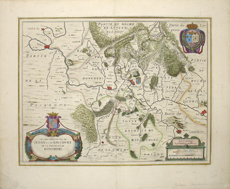
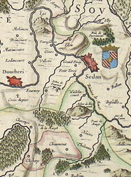
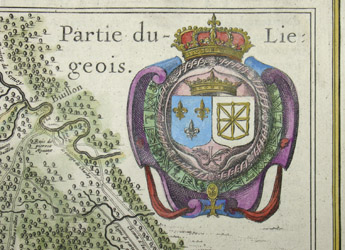
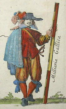
Blaeu’s maps from this series show mountains as raised topography, embellished with images of trees in bird’s-eye view clustered in wooded areas. The elaborate baroque cartouches are richly colored, generally incorporating the coat of arms of the region, and some decorated with more coats of arms. Additional cartouches show relative scales. Some maps have symbols identified in keys representing cities, burgs, villages, hamlets, chateaux, and abbeys; some are decorated with illustrations of people of the region. The outline colors vary. Some of the plates incorporate two or more maps on a single sheet.

The Blaeu family of cartographers, founded by Willem Janszoon Blaeu (1571-1638) in about 1604, became the largest printer in 17th century Europe and the leading cartographic publisher during the golden age of Dutch map making. Read more about the firm in our Guide to Globe Makers.

Condition: Generally very good with only minor overall toning, wear, soft creases. Vertical center fold as issued. Colors bright.

References:

Fleet, Christopher. “Joan Blaeu.” Pont Maps Biographies. National Library of Scotland. 2000. http://www.nls.uk/pont/bio/blaeu.html (17 September 2002).

Tooley, R.V. Maps and Map-Makers. 4th Ed. New York: Bonanza Books, 1970. pp. 33-34.

Additional information

Century

17th Century