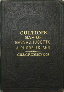

Description
Between 1831 and 1890, the Colton firm dominated American map publishing and their atlases were the finest produced in the U.S. during the 19th century. The company was founded by Joseph Hutchins Colton (1800-1893), who had no formal training in geography or cartography; he began by purchasing copyrights of maps prepared by other individuals or companies, and his principal role was to manage the production and distribution of the maps. His first maps were drawn by the esteemed cartographer David H. Burr in the 1830s. By the 1850s Colton was also publishing guidebooks, atlases and immigrant and railroad maps. The firm was renamed G.W. & C.B. Colton in the 1860s when Colton was succeeded by his sons — George Woolworth Colton (1827-1901) and Charles B. Colton (c. 1831-1916). It is believed that George Colton compiled the company’s 1855 Atlas of the World and served thereafter as the firm’s principal map compiler, cartographer and engraver.
Joseph H. Colton sold his atlas plates to Alvin Jewett (A.J.) Johnson in 1860. Johnson, the publisher, is best known for his atlases, issued in many editions in the second half of the 19th century, beginning with the publication of Johnson’s New Illustrated (Steel Plate) Family Atlas. In 1898, the G.W. & C.B. Colton firm became Colton, Ohman & Co. and published under that name until about 1901, when August R. Ohman began publishing under his own name as “successor to the Coltons.”
Full publication information: “Published by G.W. and C.B. Colton & Co. No. 172 William St. New York. 1874. Entered according to Act of Congress in the Year 1855, by J.H. Colton & Co. in the Clerks Office of the District Court of the United States for the Southern District of New York.”
Condition: Generally very good, the map with the usual overall light wear, toning, soiling, handling, spotting, soft creases. Usual light wear, faint browning, and minor openings at fold intersections. Covers very good with usual light overall toning, wear, soiling abrasions.
References:
Cohen, Paul E. and Augustyn, Robert T. Manhattan in Maps: 1527-1995. New York: Rizzoli, 1997. p. 120.
Ristow, Walter W. American Maps & Mapmakers: Commercial Cartography in the 19th Century. Detroit, MI: Wayne State University Press, 1985. pp. 325, 327.