


Description
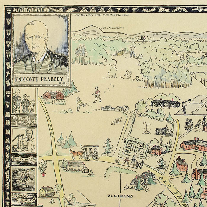
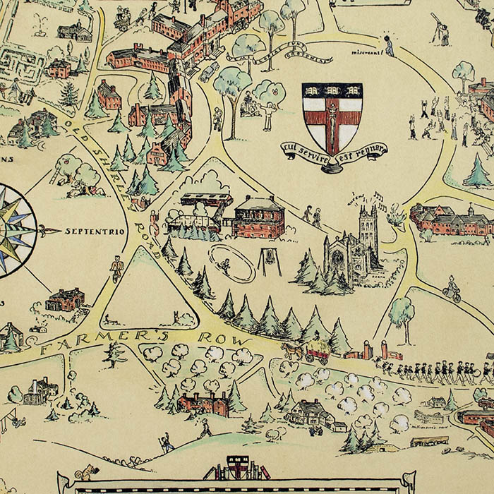
In each corner of the map are portrait illustrations of founder Endicott Peabody; “Mrs. Peabody” (presumably his wife); the late classical scholar, faculty member, and trustee of the school William Amory Gardner (1863-1930); and Reverend Sherrard Billings, one of the three original masters at the school. Small illustrations down the left and right border depict school rituals, buildings, and references to school history. The school seal is pictured in the center of the Circle, and a compass rose is on the left. The title is presented on a banner in the lower center with the school seal, books, and a squirrel on top. It is surrounded by a narrow pictorial border with tiny illustrations of sporting equipment, school supplies, and symbols of activities such as drama against a black background.
The Groton School was founded as a school for boys in 1884 by minister and educator Reverend Endicott Peabody. His vision was a school for upper class children with high academic standards and a warm, “family” atmosphere. Landscape architect Frederick Law Olmsted designed the Circle, the path around which the central buildings are arrayed. Among its graduates are President Franklin Delano Roosevelt. Since 1975, female students have been admitted and today it is fully co-educated.
Rosalind Howe Sturges [Allen] was an artist and architectural cartographer known for her illustrated pictorial maps that place historic buildings in a geographic context. Born Rosalind Howe, she was the daughter of an antiques dealer and an architect, and became interested in historic architecture at a young age. Sturges (her married name, which she used professionally for most of her life) made her first pictorial map of Vassar College the year she graduated, in 1928. Most of her pictorial maps were commissions and depicted locations in New England and the Mid-Atlantic region, including Annapolis, Maryland; Bristol and Providence, Rhode Island; Chestnut Hill, Fairmount Park, and Philadelphia, Pennsylvania; Blackstone Valley, Deerfield, Groton, Hingham, Princeton, and Worcester, Massachusetts; and the campuses of Wellesley College (1943) and Vassar College (1928). Among her major bird’s-eye view maps is her wall map Philadelphia (1971) “whose architecture reflects three centuries of cultural amity,” published by Girard Bank. Perhaps her best-known map was New England’s Architectural Heritage, 1636-1886 for Yankee magazine’s special U.S. Bicentennial issue in 1976. Widowed in 1975, Howe married her second husband Dana Allen in 1983. Today Vassar College houses her papers, including the preparatory drawings, photographs and research materials for her maps.
Condition: Generally very good recently professionally cleaned, deacidified, and removed from cardboard backing with only light remaining toning and wear, and minor remaining glue residue on the back.
References:
“Guide to the Rosalind Howe Sturges Allen Papers ca. 1928-1999.”Archives and Special Collections Library, Vassar College Libraries. July 2011. http://specialcollections.vassar.edu/findingaids/howe_rosalind.html (29 May 2020).
“History.” Groton School. 2019. https://www.groton.org/about/history (25 May 2020).
Patkus, Ronald D. “Treasured Maps: Rosalind Howe ’28.” Vassar College Alumnae/i Quarterly. Spring 2002. http://vq.vassar.edu/issues/2002/02/features/treasured-maps.html (20 January 2014).
“Philadelphia. Rosalind H. Sturges.” David Rumsey Historical Map Collection.https://www.davidrumsey.com/luna/servlet/detail/RUMSEY~8~1~272114~90045917:Philadelphia–Rosalind-H–Sturges?sort=Pub_List_No_InitialSort%2CPub_Date%2CPub_List_No%2CSeries_No&qvq=q:sturges;sort:Pub_List_No_InitialSort%2CPub_Date%2CPub_List_No%2CSeries_No;lc:RUMSEY~8~1&mi=3&trs=8 (29 May 2020).
“William A. Gardner, Greek Scholar, Dies.” New York Times. 9 February 1930. p. 28. https://timesmachine.nytimes.com/timesmachine/1930/02/09/92072075.html?pageNumber=28 (25 May 2020).