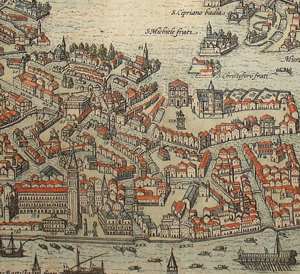
Click main image below to view enlargements and captions.

View, Italy, Venice, Venetia, Braun and Hogenberg, Antique Print

$3,750

Georg Braun (1541-1622) and Frans Hogenberg (1535-1590)
Venetia [Venice]
from Civitates Orbis Terrarum
Cologne: 1572-1617
Hand-colored engraving
13 x 18.75 inches, platemark
15.75 x 21 inches, overall
$3,750

Bird’s-eye view of Venice, from Civitates Orbis Terrarum, an important 16th-century series of city and town views. The detailed engraving captures the city when it already had become an important Italian cultural center, documenting its buildings and extensive network of bridges and canals. The view shows important landmarks. Among them are the Piazza San Marco, with its famous basilica, Campanile (bell tower) and tall columns supporting statues of the Lion of Venice and St. Theodore. The many small islands surrounding the city are also depicted and labeled, such as the Island of San Giorgio with its Palladian church and monastery as well as Murano, where glass-making workshops were located. Ships, boats and gondolas traverse the waterways. Below the view, a vignette illustrates a procession of the doge of Venice (chief magistrate and government official) accompanied by other officials, each labeled with their title or role. On either side of the vignette, a numbered key corresponding to numbers on the view lists 35 principal canals and over 125 palaces, churches, convents, monasteries, bridges, hospitals and another important structures. These include the Arsenal, the bridge over the Rialto Canal and the location of the Jewish ghetto.

Product Description Continues Below

Description

Braun & Hogenberg were co-publishers of the monumental Civitates Orbis Terrarum, the earliest systematic city atlas. Designed as a companion to Abraham Ortelius’ Theatrum Orbis Terrarum world atlas, this enormous work, which was expanded to incorporate over 500 plans and views, is one of the most ambitious book production ventures of all time, and certainly among the greatest achievements in the history of cartography. Georg Braun, a Canon of Cologne Cathedral, compiled the accompanying text, printed on the reverse. Most of the engravings were made by Simon Novellanus and Frans Hogenberg. Many of the plates were engraved after original drawings by Joris Hoefnagel (1542-1600), who travelled extensively throughout Europe.

Condition: Generally very good, recently professionally cleaned and deacidified with minor remaining toning, wear, soft creases. Very faint remaining dampstain slightly evident on backside and barely visible on front in some portions of the outer blank margins. Backstrip element removed and professionally flattened and strengthened. Some parts of corners and margins professionally reinforced verso to repair few extremely small marginal tears or weaknesses in paper.

Additional information

Century

Late 16th/Early 17th Century