Description
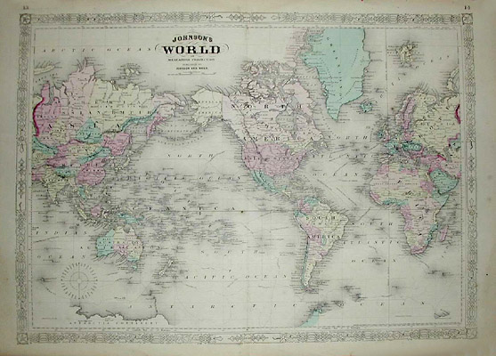
Alvin Jewett (A.J.) Johnson, the publisher, is best known for his atlases, issued in many editions in the second half of the 19th century, beginning with the publication of Johnson’s New Illustrated (Steel Plate) Family Atlas. Apparently Joseph H. Colton of the Colton family of cartographic publishers sold his atlas plates to Johnson in 1860: the title page credits Johnson and Joseph H. Colton with the supervision of the compilation, drawing and engraving, and is copyrighted by Johnson & Browning, “Successors to J.H. Colton and Company.” The plates were based upon maps from previous Colton publications, although the decorative borders are different. Later editions of the Family Atlas published in 1862 and 1863 are credited to Johnson and Ward, “successors to Johnson and Browning.” Editions continued to be published in New York until 1885.
The Colton maps that Johnson took over were engraved on steel plates and then transferred to lithographic stones for printing, rather than being produced using the cheaper wax engraving method commonly used by other U.S. map publishers in this period. Scholars speculate that the Coltons chose the method for its better quality, having set their sights on competing with European publishers in the higher-end atlas market. A.J. Johnson also published separately issued maps with D.G. Johnson and others.
Condition: Generally very good with the usual light toning, wear, soiling. Central fold, as issued.
Reference:
Ristow, Walter W. American Maps and Mapmakers: Commercial Cartography in the Nineteenth Century. Detroit: Wayne State University Press, 1985. p. 325.