
Description
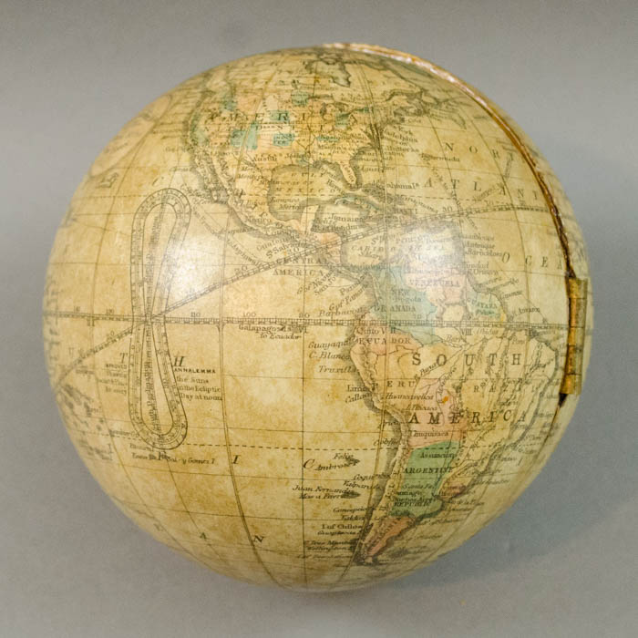
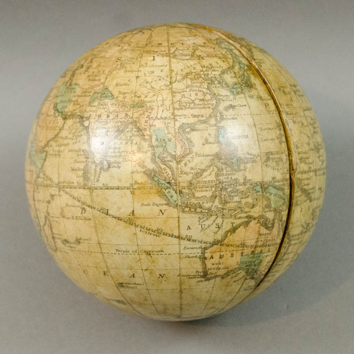
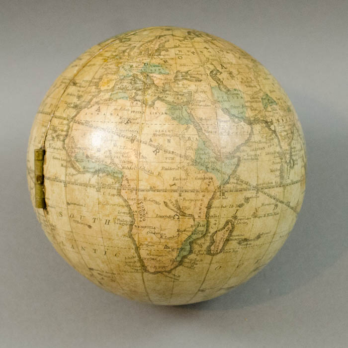
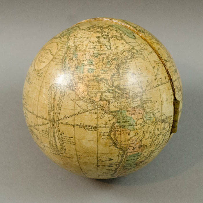
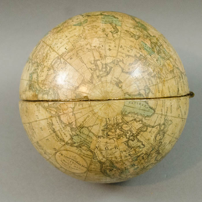
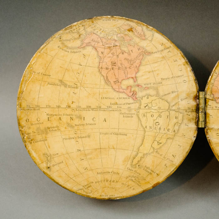
The cartography of the globe is fairly detailed, including nation and city names, international shipping routes, and transatlantic submarine cables. In the United States, state outlines are depicted in dotted line. Notable cities named include New York, Philadelphia, Washington, Savannah, St. Augustine, Nashville, Cincinnati, St. Paul, San Francisco, Sante Fe, and El Paso. The modern-day panhandle of Oklahoma is included in Texas state borders (though it had been ceded to 3 states in 1854) and the remainder of what is now Oklahoma is marked “Ind. Territory.” These boundaries reflect the creation of the nation’s first Indian Territory in 1834 in response to the 1830 Indian Removal Act, which expelled southern aboriginal natives (Cherokee, Chickasaw, Choctaw, Creek, and Seminole) and forcibly relocated them to modern-day Oklahoma. This boundary would remain in place until the 1890 Oklahoma Organic Act. “Dacota” is shown as one contiguous region, not yet divided into North and South. The “Y. Stone River” is marked, though there is no mention of the national park, which was designated a national landmark in 1872.
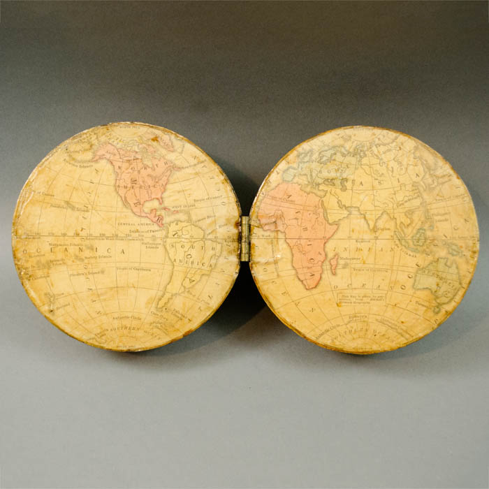
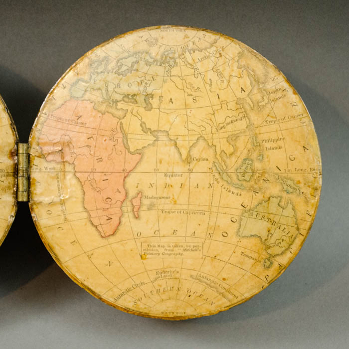
According to a printed citation on the flat interior of the globe “this Map is taken, by permission, from “Mitchell’s Primary Geography.” This reference is to a series of standard widely published school geography study atlases by Augustus Mitchell of Philadelphia, one of the most prolific atlas and map publishers in the United States in the second half of the 19th century. The hinge of the globe is hidden by the interior hemispheric map which overlays it. The interior map cartography is simple, with oceans, continents, and only a few major rivers featured. Oceans and continents are cream colored, continents are surrounded by thin hatch marks in the oceans and highlighted with thick outlines in shades of red, green, and tan. In North America, there are no state or country boundaries and only the Arctic Circle, Newfoundland, Mississippi R., and St. Lawrence R. are mapped and named. The Equator, Tropics of Cancer and Capricorn, and the Arctic and Antarctic Circles are present on both the outer and inner sections and the poles are labelled. The equator is graduated by degrees.
The 5-inch hemisphere globe was featured in the 1871 “School Materials” Schermerhorn catalog as one of two versions of “Our New School Globe.” It is included as the first entry in the globe section of the catalog as a 5-inch terrestrial globe on a simple stand. It was also offered as a five-inch hemisphere globe that opens in half on a hinge to reveal flat Western and Eastern hemisphere map.The descriptive text is as follows:
OUR NEW SCHOOL GLOBE.
Probably the principal reason why so few of our schools are supplied with a globe is that there has been no good globe to be obtained at a moderate price.
Our new five-inch Terrestrial Globe will precisely supply this want. The map is new—clearly and finely engraved—prepared expressly for taking the place of the large and expensive globes. The ‘Grand Divisions’ are boldly colored. The water is white, distinctly showing the principal Islands, Peninsulas, Capes, Gulfs, Bays, etc., etc. It is mounted in a light and durable manner, strong brass mountings, inclined axis, on a neat black-walnut stand. Securely packed in box with sliding cover. Price: $2.25”
A Hemisphere Globe (made by cutting a solid five-inch globe through the Poles), showing also the two Hemispheres on a flat surface, will be found a great convenience to the teacher. The two parts are united by a brass hinge. Price: $2.00”
Hemisphere globes like the offered example —a standard spherical globe cut in half and hinged at the center to reveal a double hemisphere flat map inside — were an innovation of American globe makers and were produced by several different companies. The form was first commercially produced in both a 3-inch and 5-inch globe by Holbrook & Co., Berea, Ohio in the 1840s. Updated versions were produced by the successor company, the Holbrook Apparatus Mfg. Co., Wethersfield, Connecticut in the 1850s. Later in the 19th Century A.J. Andrews of Chicago produced a 5-inch hemisphere globe – some of which bear the Holbrook or O.D. Case & Co. name as well. The Schedler globe markers of New Jersey produced a 6-inch one.
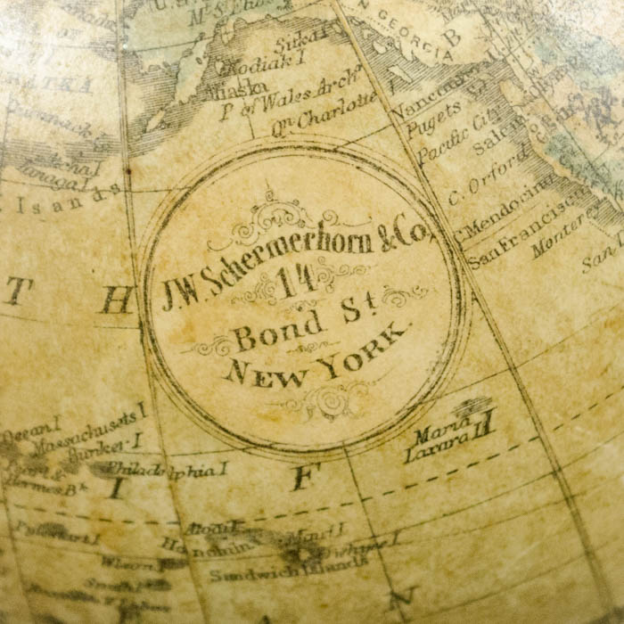
J.W. Schermerhorn & Co. of New Bond Street, New York City, was an American publisher, school supplier, and globe maker active in the second half of the 19th Century. The owner, J.W. Schermerhorn had a broad interest in various aspects of the field of education, including the American Institute which dealt with hiring instructors and outreach to parents. The eponymous company specialized in publishing educational materials, including the “American Educational Cyclopaedia,” a comprehensive resource aimed at enhancing educational standards. In 1871, the firm issued a “School Material” catalog. In a foreword, the catalog addressed “all friends of education” and extolled it as “the most complete and elaborate Manual of School Material ever published … to contribute our full share towards supplying the material necessary in educating the six millions of children who live on American soil.” The catalog was extensive, featuring globes and planetaria in addition to pupils’ and teachers’ desks and chairs, bookshelves, gymnastic apparatus, blackboards, school stationery, educational diagrams, and schoolbooks produced by Schermerhorn and various other manufacturers.
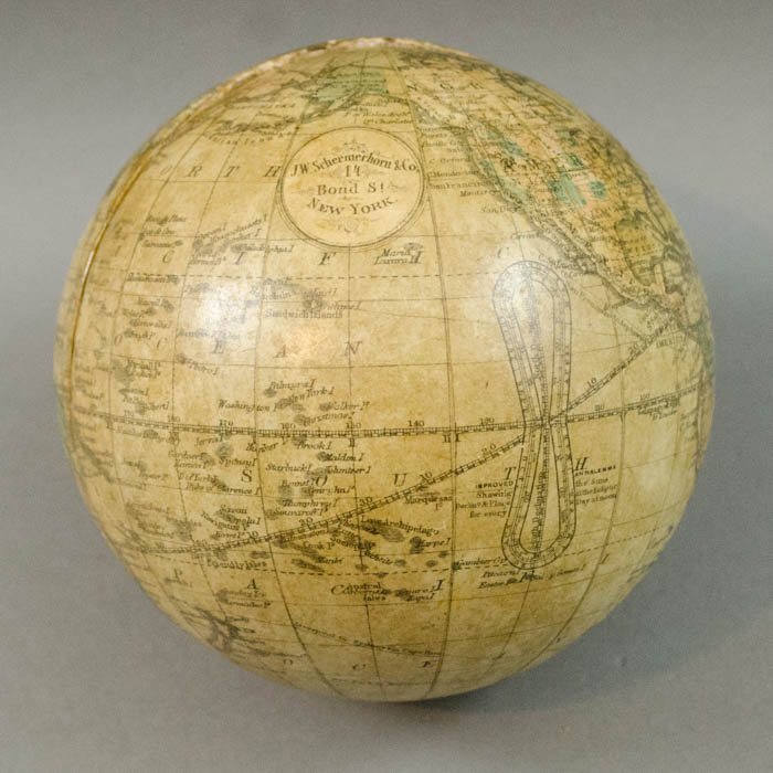
Circular cartouche: “J.W. Schermerhorn & Co. / 14 Bond St / New York
Condition: Generally very good with the usual overall light toning, handling, wear. Few scattered minor abrasions professionally restored.
References:
School Material, New York: J.W. Schermerhorn & Co., 1871.
Warner, Deborah Jean. “The Geography of Heaven and Earth,” Rittenhouse Journal of the American Scientific Instrument Enterprise, Vol. 2, No. 4. 1987. p. 128 (discussion in entry about Shepherd slate globes).