
⊕ Click main image below to view enlargements and captions.


2002, Museum Exhibition, Forged by Fire, India House Club, Manhattan, Antique New York City Maps
Forged by Fire
India House Club
Special Exhibition: September 25, 2002 to January 5, 2003
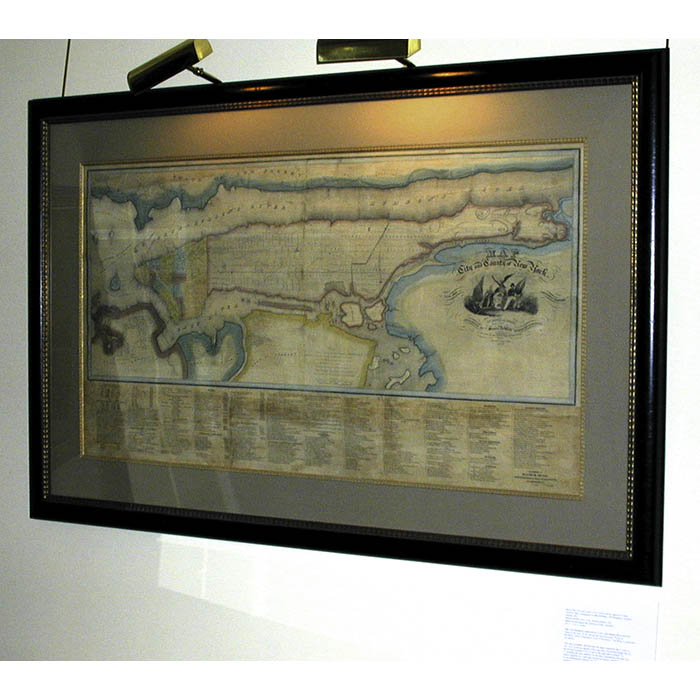
The George Glazer Gallery loaned two early 19th-century maps of New York City to the exhibition Forged by Fire, organized by India House to honor the anniversary of September 11, 2001. The exhibition documents the history of Hanover Square, “New York’s First World Trade Center” and New York’s victory over disaster in previous generations. The centerpiece of the exhibition is an 11-foot iron anchor unearthed during construction of the World Trade Towers in the late 1960s, shown with art and artifacts documenting fires that destroyed large areas of Lower Manhattan in 1776, 1835, 1845 and 1853. These events from New York’s history are presented as an inspiration to Lower Manhattan’s regeneration in the 21st century. One was David Burr’s Map of the City and County of New York: 1832, a large wall map produced when the population of the city was concentrated below 14th Street and the rest was countryside. The other was Plan Of the City Of New York, With The Recent And Intended Improvements Drawn from Actual Survey By William Bridges, City Surveyor, 1807 published by Isaac Riley. See the Burr and Riley maps on our website.
Related products
-

Gavel, Relic, Wood, Maritime, USS Sperry, Vintage, 1982 (Sold)
-

Globe, American, Rand McNally, Terrestrial World, 8-Inch Table Globe, 4-leg Wood Stand, Chicago, c. 1920s
$1,650 -

Neoclassical, Art, Mythology, Cupid, Pair Antique Prints, Paris, late 18th Century
$1,150 -
![Temple de Vesta à Rome [Temple of Vesta at Rome], Plate 42](https://www.georgeglazer.com/wpmain/wp-content/uploads/2017/02/despouy-vesta-pl42-300x300.jpg)
Art, Architecture, Ancient Greece and Rome, D’Espouy, Antique Prints, Paris, c. 1900