Frederick de Wit (1630-1706)
Occidentalior Tractus Indiarum Orientalium à Promontorio Bonae Spei ad C. Comorin
[A Drawing (with a Western Perspective) of the East Indies from the Promontory of Good Hope to Cape Comorin]
Louis Renard, Amsterdam: 1715
Hand-colored engraving
17.5 x 21.5 inches, plate mark
19.75 x 23.75 inches, overall
Sold, please inquire as to the availability of similar items.

Occidentalior Tractus Indiarum Orientalium
Early 18th C. de Wit Map, Indian Ocean
Early 18th C. de Wit Map, Indian Ocean
This item is sold. It has been placed here in our online archives as a service for researchers and collectors.
- Please inquire as to the availability of similar items currently in stock, or use the navigation bar above to browse our site for currently available items.
- Find guidelines for the use of images from georgeglazer.com.
- To see more archived items, view our directory.
- Find information about selling your art and antiques.
  |
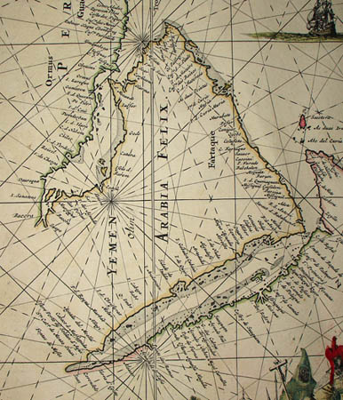 |
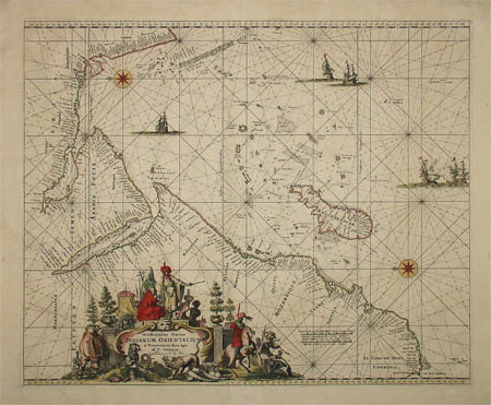
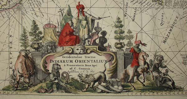
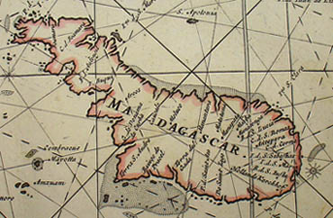
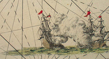
Portolan chart of the Indian Ocean and Arabian Sea oriented with East (rather than North) at the top. It shows the waters bounded from the southern tip of India at Cape Comorin to the southern tip of South Africa at the Cape of Good Hope. It also shows the coastal areas of west India, Persia, the Arabian Peninsula and East Africa, as well as Madagascar and smaller islands. Coastal cities, bodies of water and islands are named. The map is crisscrossed by rhumb lines emanating from various points on the grid. The equator and the Tropic of Capricorn are indicated by thick, vertical gray lines. A key gives the scale in Dutch and French miles. The ocean is decorated with a compass rose and clipper ships. At lower left an elaborate cartouche depicts people in regional costume and animals including a water buffalo, a leopard and a lion. The figures are not statically posed, but gesture and interact; one man sits on a rearing horse.
This map first appeared in de Wit's Zee Atlas of 1675, which was reprinted in 1715; this is that later edition. Frederick de Wit was founder of a prominent map publishing firm in 17th century Amsterdam, the golden age of Dutch cartography. The de Wit family both published their own atlases and supplied maps to other cartographers such as Hendrik Doncker. As map historian R.V. Tooley wrote, “[t]he 17th century is the century par excellence of the decorative coloured map.” De Wit’s maps exemplify that style. Some of them continued to be republished well into the 18th century.
Cartouche: Occidentalior Tractus Indiarum Orientalium à Promontorio Bonae Spei ad C. Comorin. Amstelodami à F. de Wit.
References:
"A Drawing (with a Western Perspective) of the East Indies from the Promontory of Good Hope to Cape Comorin." World Digital Library. 7 May 2009. http://www.wdl.org/en/item/2915 (22 June 2010).
Tooley, R.V. Maps and Map-Makers. New York: Bonanza Books, 1970. p. 113.