C. Smith & Son (globe gores)
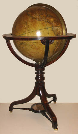
18-Inch Terrestrial Floor Globe
Henry George Collins, London: c. 1858
Mahogany tripod stand
45 inches high, 24 inches diameter
Sold, please inquire as to the availability of similar items.

Collins 18-Inch Terrestrial Globe: 1858
Floor Globe on Georgian Mahogany Tripod Stand
Floor Globe on Georgian Mahogany Tripod Stand
This item is sold. It has been placed here in our online archives as a service for researchers and collectors.
- Please inquire as to the availability of similar items currently in stock, or use the navigation bar above to browse our site for currently available items.
- Find guidelines for the use of images from georgeglazer.com.
- To see more archived items, view our directory.
- Find information about selling your art and antiques.
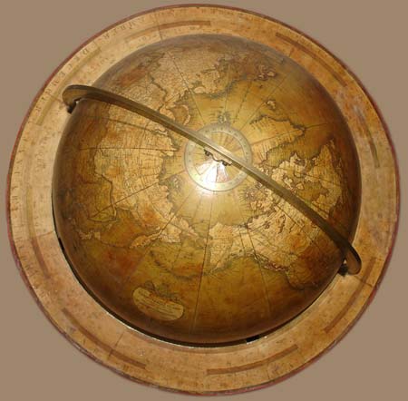
Viewed from top
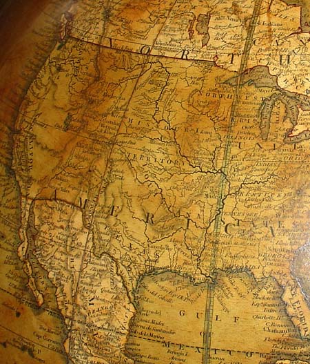
Detail of North America, showing little-explored areas labeled Missouri Territory and Northwest Territory.
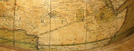
Detail of Africa showing the area above the equator labeled "Ethiopia."
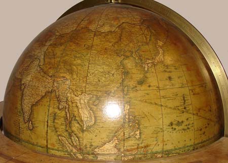
Detail of Asia
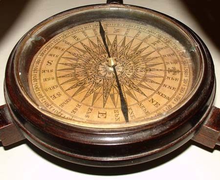
Compass
 |
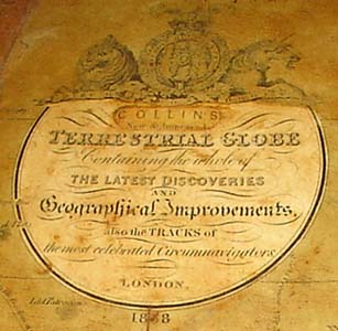 |
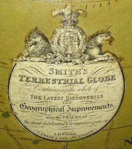
The C. Smith cartouche from a different globe (left) is almost identical to the Collins cartouche from this globe (right).
The terrestrial globe surmounted by brass hour disc at the North Pole, in full graduated brass meridian, the horizon with hand-colored calendar and zodiac. It is supported by four mahogany quadrants joined to the horizon by pairs of quarter-round brackets; raised on a mahogany tripod stand with central turned standard, the splayed legs joined by compass stretcher with glazed round wooden compass case enclosing a paper compass card and magnetized metal needle.
North American cartography includes Native American tribal areas, especially west of the Mississippi River, where there are few towns. Wisconsin is labeled Northwest Territory, the Midwest is Missouri Territory, and the area between the Pacific Coast and the Rockies is virtually void of cartographic information. Likewise, compared to Europe and Asia, the interior regions of Africa, South America and Australia are also largely uncharted, with all of central Africa near the Equator labeled Ethiopia. Shipping routes and the voyages of Cook and other explorers are marked in the oceans.
Henry George Collins was a British publisher and globe maker active in London from around 1850 to 1858. Collins mainly produced maps and atlases, notably Travelling Atlas of England and Wales, which he took over from H. Teesdale. In March 1858 he was granted a patent for "an improved method of obtaining impressions on an enlarged or diminished scale, from engraved plates, or other printing surfaces."
This globe has a cartouche identical to those of the globe maker Charles Smith & Son, when they were at 172 Strand, London (based on extant 18-inch Smith globes). In this case there is an overlabel, as issued, with the name "Collins" where the Smith name would have been. Collins presumably acquired the globe gores from the Smith firm and issued the globe under his own name, a common practice. Although the third numeral of the date of the globe beneath the cartouche is partly obscured, it is likely 1858, based on when Collins was active.
Shaped Cartouche Surmounted by Royal Coat of Arms: Collins/ New and Improved/ TERRESTRIAL GLOBE/ Containing the whole of/ THE LATEST DISCOVERIES/ and Geographical Improvements/ also the TRACKS of/ the most celebrated Circumnavigators/ London/ 18[5]8
References:
Dekker, Elly, et al. Globes at Greenwich: A Catalogue of the Globes and Armillary Spheres in the National Maritime Museum, Greenwich. London: Oxford University Press and the National Maritime Museum, 1999. p. 54.
The Repertory of Patent Inventions. T. and G. Underwood, 1858. pp. 273-276. Online at Google Books. http://books.google.com/books?id=eQULAQAAIAAJ (18 February 2010).
Tooley, R.V. Maps and Map-Makers. 4th Ed. New York: Bonanza Books, 1970. pp. 81 and 84.