Joan Blaeu (c. 1599-1673) (after)
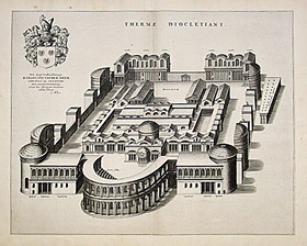
Thermae Diocletiani [Baths of Diocletian]
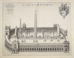
Circus Maximus
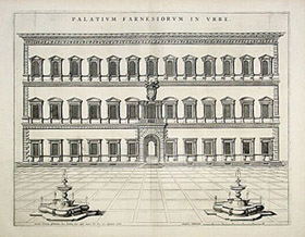
Palatium Farnesiorum in Urbe [Farnese Palace in Rome]
from
Citta del Vaticano, Roma and Napoli
Joan Blaeu (heirs), Amsterdam: 1682
or P. Mortier, Amsterdam: 1704-05
Black-and-white engravings
Sold, please inquire as to the availability of similar items.
To view other works by Blaeu, including maps and city views, type "Blaeu" in our search engine.
Precise perspectival architectural drawings depicting ancient Roman monuments, buildings and architectural complexes as they would have looked when they were first erected. Of course, during Blaeu's era they would have been partially in ruins.
This engraving was originally published by Joan Blaeu, who published three town-books of Italy during his lifetime: Citta del Vaticano, Roma and Napoli. By the year 1672, a fire largely destroyed the main Blaeu workshop, and much of the prepared material. Nonetheless, work on the town-books continued, and in 1682 the completed work was published in Amsterdam by his heirs. The town-books were a great success and reissued several times by different publishers in Amsterdam, as late as 1726. Pierre Mortier reissued all the Blaeu plates in the years 1704-05 in an atlas comprising four volumes with the imprint of “A Amsterdam Chez P. Mortier Avec Privilege.”
The Blaeu family of cartographers, founded by Willem Janszoon Blaeu (1571-1638) in about 1604, became the largest printer in 17th century Europe and the leading cartographic publisher during the golden age of Dutch map making. Read more about the firm in our Guide to Globe Makers.
References:
Fleet, Christopher. "Joan Blaeu." Pont Maps Biographies. National Library of Scotland. 2000. http://www.nls.uk/pont/bio/blaeu.html (17 September 2002).
Perowne, Stewart. Roman Mythology. New York: Paul Hamlyn, 1969. pp. 58-59.
"Rome Reborn: The Vatican Library & Renaissance Culture." Library of Congress. 2 July, 2002. http://www.loc.gov/exhibits/vatican/arch.html (17 September 2002).
Sullivan, Mary Ann. “Rome, Italy: Temple of Fortuna Virilis (Temple of Portunus).” Digital Imaging Project, MAS/BC. http://www.bluffton.edu/~sullivanm/romanvirilis/virilis.html (17 December 2004).
Tooley, R.V. Maps and Map-Makers. 4th Ed. New York: Bonanza Books, 1970. pp. 33-34.