Edward Wells (after)
Michael Burghers (c. 1653-1727) (engraver)
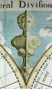
A New Map Of The Terraqueous Globe According To The Ancient Discoveries And Most General Divisions Of It Into Continents And Oceans
Oxford: c. 1700-1738
Engraving on laid paper with Strasburg Bend & Lily watermark [Churchill 434]
17.25 x 21.25 inches overall
14.5 x 20.5 inches image
Sold, please inquire as to the availability of similar items.

Map Of The Terraqueous Globe
Edward Wells, c. 1700-1738
Edward Wells, c. 1700-1738
This item is sold. It has been placed here in our online archives as a service for researchers and collectors.
- Please inquire as to the availability of similar items currently in stock, or use the navigation bar above to browse our site for currently available items.
- Find guidelines for the use of images from georgeglazer.com.
- To see more archived items, view our directory.
- Find information about selling your art and antiques.

  |
 |
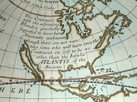 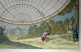 |
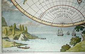
Instructional map which depicts the world in classical times, a companion piece to a map of the modern world, both of which were published by Edward Wells, teacher of mathematics and geography at Christchurch College of Oxford University. Wells labels North America as Atlantis and offers this speculation that the New World is in fact the legendary "lost continent": "This Continent with the adjoining islands is generally supposed to have been Anciently unknown though there are not wanting some, who will have even the Continent itself to be no other than the Insula Atlantis of the Ancients." California is shown as an island. Below the hemispheres is a vignette dedicated to His Highness William, Duke of Gloucester, who appears with his tutor under the tree on the right. The 13-year-old William, heir to the throne, began studies at Christchurch in 1700 at the age of 11, and died a few months after the map was issued. On either side of this are small landscapes, one of ships arriving in the New World and one of the Radcliffe Camera in Oxford.
Michael Burghers was an engraver and draftsman from Holland, who came to England and settled in Oxford in 1673. There he worked under David Loggan and succeeded him as Engraver to the University. Burghers engraved the first Oxford Almanack in 1676, and continued to engrave most of them for the next 43 years. He also illustrated books and produced architectural, botanical and portrait engravings.
References:
Mackenzie, Ian. British Prints: Dictionary and Price Guide. Woodbridge, Suffolk, England: Antique Collectors Club, 1987. p. 69.
Redgrave, Samuel. A Dictionary of Artists of the English School: Painters, Sculptors, Architects, Engravers and Ornamentists. London: Longmans, Green, and Col., 1874. p. 60.
Shirley, Rodney W. The Mapping of the World: Early Printed World Maps 1472-1700. London: Holland Press, 1983. Pl. 419.