Mappe-Monde [World Map]
France: Early 19th Century
Pen and ink and watercolor on paper
12 x 16.25 inches
Sold, please inquire as to the availability of similar items.

Mappe-Monde
Original French Design, Early 19th Century
Original French Design, Early 19th Century
This item is sold. It has been placed here in our online archives as a service for researchers and collectors.
- Please inquire as to the availability of similar items currently in stock, or use the navigation bar above to browse our site for currently available items.
- Find guidelines for the use of images from georgeglazer.com.
- To see more archived items, view our directory.
- Find information about selling your art and antiques.
![Mappe - Monde [World Map]](images/mappemondedbl.JPG)
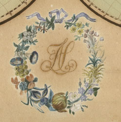
Finely rendered double hemisphere world map, oceans colored light blue, continents outlined in red, blue or green/yellow. North and South America called "Amerique Septentrionale" and "Amerique Meridionale," respectively. United States labeled along East Coast as "Etats-Unis." Louisana indicated, probably as a territory. Australia shown as "Nouvelle Holland." Antarctica not indicated. Map title in gold centered above map and artist's initials in gold, centered in ribbon-tied floral wreath below map.
In 19th century European and American schools and private education, it was common for female students to practice geography and drawing by making maps in pen and ink and watercolor. This one is particularly well-executed.