Democratic Party (published for)
How the Public Domain Has Been Squandered
Rand McNally & Co., Chicago: c. 1884
Black and white woodblock print
23.5 x 16.5 inches, overall
Sold, please inquire as to the availability of similar items.

Democratic Party Political Poster and Map
Rand McNally, Chicago: 1884
Rand McNally, Chicago: 1884
This item is sold. It has been placed here in our online archives as a service for researchers and collectors.
- Please inquire as to the availability of similar items currently in stock, or use the navigation bar above to browse our site for currently available items.
- Find guidelines for the use of images from georgeglazer.com.
- To see more archived items, view our directory.
- Find information about selling your art and antiques.

 |
 |
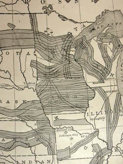 |
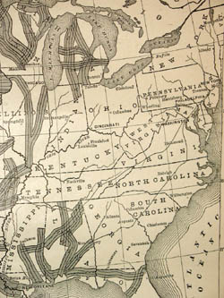
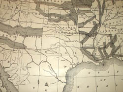
Democratic Party campaign poster produced during the contentious elections in 1884, prominently featuring a map. The map of the United States is shaded to visually underscore the argument of the text, that the Republicans in Congress were far too beholden to the railroad companies, and had given away an enormous amount of public land for construction of westward leading rail lines. One of the many issues in the 1884 presidential election between Democratic candidate Grover Cleveland and his Republican opponent, a senator and house speaker James Blaine, was Blaine's close relations with railroad interests. Cleveland narrowly won the election, partly due to the votes of reform-minded Republicans.
The map was published by Rand McNally, which was already one of the leading U.S. map publishers, and is illustrated in one of the definitive reference books on 19th century American maps (Ristow, 477). Another example of this map sold in 2005 for $1,955, including buyers premium, at Swann Galleries (150 Rare & Important Maps & Atlases from the Mark Babinski Collection, December 8, 2005, Sale 2060, Lot 100).
Complete upper title and caption: “How the Public Domain has been Squandered. Map showing the 139,403,026 acres of the people's land -- equal to 871,268 Farms of 160 acres each. Given by Republican Congresses to Railroad Corporations. This is more land than is contained in New York, New Jersey, Pennsylvania, Ohio, and Indiana.”
Complete lower caption: “We believe that the public lands ought, as far as possible, to be kept as homesteads for actual settlers; that all unearned lands heretofore improvidently granted to railroad corporations by the action of the Republican party should be restored to the public domain; and that no more grants of land shall be made to corporations, or be allowed to fall into the ownership of alien absentees. – Democratic Platform, 1884.”
References:
"Election of 1884." U-S-History.com. 2002-2005. http://www.u-s-history.com/pages/h738.html (15 December 2005).
Ristow, Walter W. American Maps and Mapmakers: Commercial Cartography in the Nineteenth Century. Detroit: Wayne State University Press, 1985. p. 477.