[Humphrey Phelps]
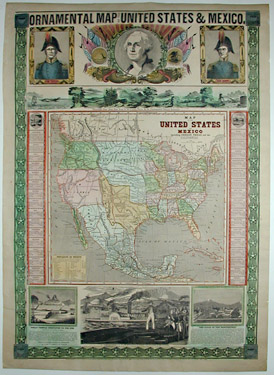
Ornamental Map of the United States & Mexico
Ensign & Thayer, 50 Ann Street, New York: 1848
Rufus Blanchard, Cincinnati, Jos. Ward, Boston, D. Needham, Buffalo (printers, publishers or sellers)
Hand-colored lithograph
31 x 23 inches
Sold, please inquire as to the availability of similar items.

Ornamental Map of the U.S. and Mexico
1848
1848
This item is sold. It has been placed here in our online archives as a service for researchers and collectors.
- Please inquire as to the availability of similar items currently in stock, or use the navigation bar above to browse our site for currently available items.
- Find guidelines for the use of images from georgeglazer.com.
- To see more archived items, view our directory.
- Find information about selling your art and antiques.
 |
 |
 |
 |
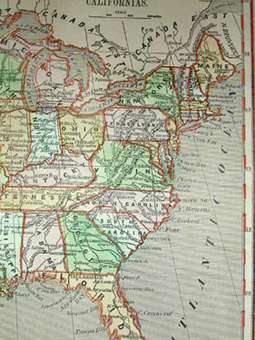
Highly decorative historical and pictorial broadside map of the United States issued during the U.S.-Mexican War. At the center is a "Map of the United States and Mexico, Including Oregon, Texas and the Californias." Texas is shown as a Republic before statehood. In Texas it is noted that "The Texians claim as their Boundary the Rio del Norte." Territories include Sioux District, Missouri Territory, Oregon Territory, New California, New Mexico, and Indian Territory.
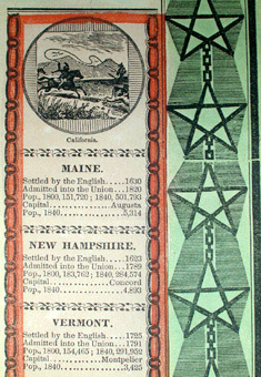
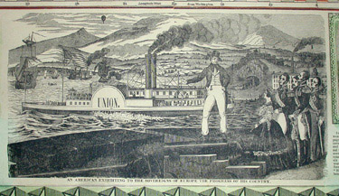
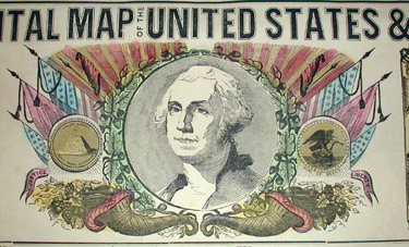
Decorative border flanking map with statistical data for states and territories. "Panoramic View from New York to the Pacific Ocean by the Contemplated Oregon Railroad" in border above map. Top portion of broadside having decorative portraits of General Zachary Taylor and General Winfield Scott, heroes of the U.S.-Mexican War, flanking a central portrait of George Washington within cartouche of oak leaves, seals, cornucopia, flags, etc. Lower margin having views of Mexico: "Great Temple Dedicated to the Sun" and The Halls of the Montezumas," and with a pictorial representation of "An American Exhibiting to the Sovereigns of Europe the Progress of his Country." Star-form outer border with United States shields in each of the four corners.
Tensions between the U.S. and Mexico were building in 1845 when the U.S. president James Polk prepared to annex Texas and sent an emissary to Mexico to try to purchase New Mexico and California. General Taylor was sent to Texas in 1845 and led the army there when Congress officially declared war in 1846. Early in 1847, General Scott took command of some of Taylor's troops and occupied Los Angeles, then marched southward, eventually capturing Mexico City. A peace treaty was signed in July 1848, ending the war.
This map was first published in 1846 (by Phelps & Ensign), with another edition in 1847, and this much revised 1848 edition. It is typical of the highly decorative and overtly patriotic maps produced by this firm and its successors.
Timothy (1795-1849) and Edward Ensign were lithographers in New York City, active in a series of partnerships between 1841 and 1861, working with Phelps and Humphrey, as Ensign & Thayer (with Horace Thayer), and finally, as Ensign, Bridgman & Fanning. Over their career they produced a number of notable prints on subjects from American history as well as maps and U.S. traveller's guides.
References:
Baucom-Huffman, Kaye (dir.). "The U.S. and Mexican War." KERA PBS Online. Dallas, Texas: 1998. http://www.pbs.org/kera/usmexicanwar/mainframe.html (14 May 2002).
Peters, Harry T. America on Stone. U.S.: Doubleday, Doran, 1931, p. 181.