Louis Aloys Risse (1850-1925) (cartographer)
Board of Public Improvements, Topographical Bureau (produced by)
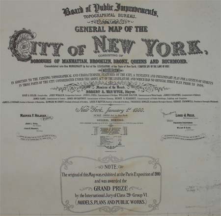
General Map of the City of New York
Robert A Welcke, New York: c. 1900-10
Photolithograph on paper, mounted on linen, bound with selvedge
55.5 x 48 inches
Sold, please inquire as to the availability of similar items.

Huge Wall Map of the City of New York
Louis Aloys Risse, c. 1900-10
Louis Aloys Risse, c. 1900-10
This item is sold. It has been placed here in our online archives as a service for researchers and collectors.
- Please inquire as to the availability of similar items currently in stock, or use the navigation bar above to browse our site for currently available items.
- Find guidelines for the use of images from georgeglazer.com.
- To see more archived items, view our directory.
- Find information about selling your art and antiques.

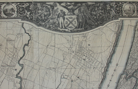
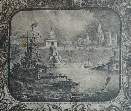
Huge and impressive wall map of New York City. The original was even larger a mural-sized 27 x 31 feet and was exhibited at the Paris Exposition in 1900, where it was awarded the Grand Prize. Manhattan and each borough are shown in great detail, exactly at the turn of the century, January 1, 1900. The elaborate foliate border features New York City seal, dozens of miniature views of buildings and local sites, and four larger vignette views, one in each corner: Riverside Park from Hudson River, New York from Statue of Liberty, New York Harbor and the Harlem River from Washington Bridge. Waters indicated in blue, boroughs outlined in pink, parks indicated in green.
Louis Aloys Risse was the chief engineer of the New York City Topographical Bureau and is probably best known as the designer of the Grand Concourse in the Bronx. In 1898, Greater New York City had been created by consolidating Manhattan and the other four boroughs that still make up the city today. The following year, Risse suggested the map to the Board of Public Improvements to promote the newly configured city as a major world metropolis at the upcoming Paris Exposition. $10,000 was appropriated for its construction and Risse oversaw a team of 8 surveyors and 12 draftsmen who worked rapidly to complete the project in time for the exposition. The resulting map not only documents what existed, but Risses ideas for future development, including a network of boulevards and parks, diagonal streets and wide highways. Although most of the roads that Risse proposed were never built, several parks in Queens and Staten Island later were. When the map went on display at the Paris Exposition, visitors stood on a three feet high platform to view it. The gargantuan map had the hoped-for result as an extremely popular and award-winning exhibit. The fate of the original map becomes murky after 1914, but it apparently was destroyed during a move of city offices or in a subsequent fire. Smaller versions are all that remain, including this one; a version published in 1900 at 7 feet 4 inches by 8 feet 8 inches, one of which is in the collection of the New York Public Library; and another at approximately eight by twelve feet in the collection of the Library of Congress. The latter is described and illustrated in Manhattan in Maps (see References below).
Map Cartouche: General Map of the City of New York, Consisting Of Boroughs Of Manhattan, Brooklyn, Bronx, Queens, And Richmond. Consolidated Into One Municipality By Act Of The Legislature By The State Of New York, (Chapter 378 Of The Laws Of 1897.) Showing In Addition To The Existing Topographical And Characteristic Features Of The City, A Tentative And Preliminary Plan For A System Of Streets In Those Parts Of The City Consolidated Under The Above Act Of The Legislature And Which Had No Official Street Plan Prior 1898. Members Of The Board, Robert A.Van Wyck, Mayor.
Additional Cartouche: The Original Of This Map Was Exhibited At The Paris Exposition Of 1900 And Was Awarded Thee Grand Prize By The International Jury Of Class 29 -- Group VI. (Models, Plans And Public Works.)
References:
Cohen, Paul E. and Augustyn, Robert T. Manhattan in Maps: 1527-1995. New York: Rizzoli, 1997. pp. 144-146.
"General Map of the City of New York." New York Public Library. http://catalog.nypl.org/record=b13985724*eng (28 January 2010).
"Map of New York for Paris: Details of the Immense Topographical Work in Preparation for Exposition." New York Times. 10 December 1899. Online at http://query.nytimes.com/mem/archive-free/pdf?_r=1&res=9402E3DF1238E733A25753C1A9649D94689ED7CF&oref=slogin (28 January 2010).