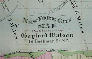
New York City Map
Gaylord Watson, New York: 1871 (map)
Humphrey Phelps, New York: 1865, 1873 (guide)
Hand-colored engraving
16.25 x 28.75 inches, overall
Sold, please inquire as to the availability of similar items.

New York City Map
Humphrey Phelps, New York: 1865
Humphrey Phelps, New York: 1865
This item is sold. It has been placed here in our online archives as a service for researchers and collectors.
- Please inquire as to the availability of similar items currently in stock, or use the navigation bar above to browse our site for currently available items.
- Find guidelines for the use of images from georgeglazer.com.
- To see more archived items, view our directory.
- Find information about selling your art and antiques.

 |
 |
 |
 |
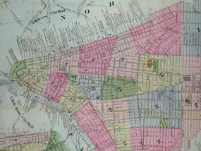
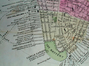
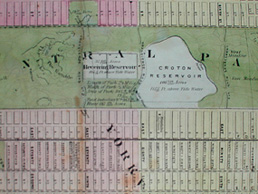
Map of the city showing all streets and railroads and having the separate wards colored in shades of red, pink, green, blue, and yellow. Waters colored blue. This rather detailed rendition of the city includes the labeling of nearly every pier surrounding Manhattan in terms of its operator. Manhattan is shown from Battery Park to 111th Street , and thus includes Central Park in its entirety. Jersey City, Hoboken, and parts of Brooklyn and Long Island City are included. The asylums and hospitals on Blackwell's and Ward's Islands are also depicted. Six circle arcs depict the radius of one mile to the radius of six miles from City Hall. An intricately detailed pattern borders the map.
The map was originally issued folding within a small guide book intended for tourists: The Great Metropolis: Phelps' New York City Guide To All That Can Be Seen, and How To See It. This was a combined production of Humphrey Phelps and Gaylord Watson. Watson was a map chart and print publisher, established in New York City in 1828. The two firms also collaborated on Phelps Illustrated Guide to Central Park Map.
The lithography firm of Humphrey Phelps (also known as Phelps, Humphrey) operated in New York City in the mid 19th Century, and at various times co-publishing work with Ensign & Thayer. They produced maps, prints and books, and are known for the "Phelps Guides" series of folding maps and wall maps for travelers, which Phelps began producing in 1838.Full publication information: Map published by Gaylord Watson, No. 16 Beekman St., New York: 1871. Guide copyright Humphrey Phelps, New York: 1865, 1873.