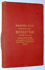
Miniature Atlas of the Borough of Manhattan in One Volume
E. Belcher Hyde, New York: 1912
Color printed plat maps
9.75 x 6.5 inches closed, overall
Quarto, red cloth
Sold, please inquire as to the availability of similar items.

Miniature Atlas of Manhattan
1912
1912
This item is sold. It has been placed here in our online archives as a service for researchers and collectors.
- Please inquire as to the availability of similar items currently in stock, or use the navigation bar above to browse our site for currently available items.
- Find guidelines for the use of images from georgeglazer.com.
- To see more archived items, view our directory.
- Find information about selling your art and antiques.
 |
 |
 |
 |
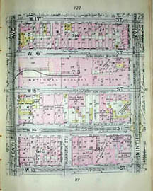 |
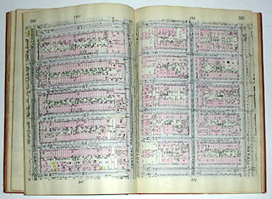
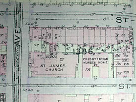
Comprehensive street atlas of Manhattan with 472 pages of detailed plat maps by E. Belcher Hyde, which created maps for the fire insurance industry. An index is provided listing all streets and the pages corresponding to them. Includes a sectional map of Manhattan. Enough detail is provided to distinguish different buildings from each other, all lots being numbered along with house numbers, dimensions, number of stories and basement, and block number. The maps are current as of March 13th, 1912. Buildings that are large or of great importance are named.
Buildings, streets, subways and city infrastructure are labeled with symbols of interest to the insurance industry. These show if the building is made of brick, stone, iron or frame building, fireproof steel or a combination such as half brick and half frame or frame building with brick front. Other symbols point out buildings with stores on the first floor, saloons or hotels with liquor licenses, stables, sheds, old buildings, greenhouses and foundations. Infrastructure symbols show opened and unopened streets, water mains with dimensions, sewer with manholes and dimensions, street dimensions, hydrants and the elevations of streets above high tide. Transportation lines are also indicated: steam railroads, elevated railroads, trolley lines and interborough rapid transit.
E. Belcher Hyde, Inc. published detailed maps for the fire insurance industry which were updated on an annual basis based on surveys by Hyde employees. The degree of detail and specificity of these maps allowed the insurance companies to estimate the liability of certain properties because they showed every structure in an area, its building materials and size, its function, and other pertinent information about the street and surroundings. The company published maps from the 1890s to at least 1991, of Manhattan, Brooklyn, Queens and Long Island.
Reference:
"Historical Maps and Atlases: Belcher Hyde and Sanborn Company Maps." Queens Borough Public Library. http://www.queenslibrary.org/central/longisland/maps_bhyde.asp (11 August 2003).