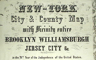
New-York City & County Map with Vicinity entire Brooklyn Williamsburgh Jersey City &c. in the 79th Year of Independence of the United States
Charles Magnus, 12 Frankfort Street, New York: c. 1855
Engraving and lithograph, uncolored, on thin rice paper
19.75 x 32.75 inches, image
21 x 34 inches, overall
Sold, please inquire as to the availability of similar items.

New York City and County Map
Charles Magnus, c. 1855
Charles Magnus, c. 1855
This item is sold. It has been placed here in our online archives as a service for researchers and collectors.
- Please inquire as to the availability of similar items currently in stock, or use the navigation bar above to browse our site for currently available items.
- Find guidelines for the use of images from georgeglazer.com.
- To see more archived items, view our directory.
- Find information about selling your art and antiques.
 |
 |
 |
 |
 |
 |
 |
 |
 |
 |
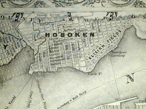
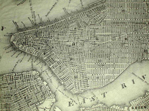
Fine, elaborately decorated mid-19th-century map of New York City and its metropolitan area issued in commemoration of the Declaration of Independence. Detailed cartography shows streets and neighborhoods of Manhattan (centered horizontally in the map), as well as those of Brooklyn, parts of present-day Queens, and Jersey City and Hoboken.
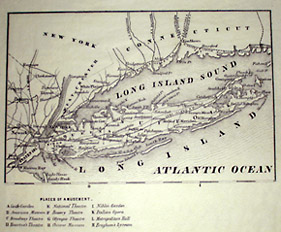
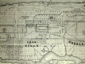
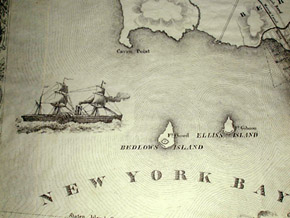
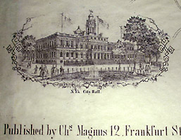
Manhattan villages of Yorkville (part of present day Upper East Side), Haerlem (present day "Spanish Harlem"), and Manhattanville (present day Harlem) indicated. Central Park had not yet been created, instead there are streets. Brooklyn villages of Bedford, Williamsburgh and Green Point shown. Ravenswood and Astoria in what is now Queens also shown. Insets include a map of Long Island and greater Metropolitan area and a vignette view of City Hall. New York Bay and the Hudson River are embellished with detailed images of steam ships.
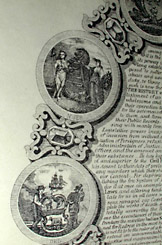
The cartouche is surmounted by the New York City coat of arms. Beneath the cartouche is the text of the Declaration of Independence, showing original signors, surrounded by oval arrangement of round state seals of the 13 original colonies. Map in its entirety surrounded by elaborate arabesque vine border.
An "Explanation" key provides letters and numbers representing universities and colleges; scientific, literary, and benevolent institutions; public buildings; and places of entertainment. These include Rutgers Female Institute, Columbia College, N.Y. University, Bellevue Hospital, Custom House, Arsenal, Castle Garden, American Museum, Bowery Theatre, and Italian Opera.
Charles Magnus was one of the largest publishers of Civil War topographical prints and city views, as well as pictorial envelopes with Civil War camp scenes, patriotic song sheets and illustrated poems. The firm's main operation was at 12 Frankfort Street in New York, with a branch office at 520 Seventh Street in Washington, D.C.