Joseph Hutchins Colton (1800-1893) (publisher)
D.G. Johnson (engraver)
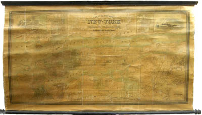
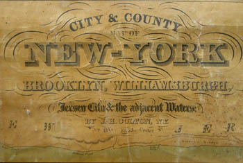
City & County Map of New York Brooklyn, Williamsburgh, Jersey City & the Adjacent Waters
J.H. Colton, 86 Cedar Street, New York: 1853 (copyrighted 1845)
Hand colored engraving, varnished, backed on linen, mounted on wooden rollers, as issued
32 x 55 inches, including rollers
27 x 52 inches, printed border
Sold, please inquire as to the availability of similar items.

Manhattan, New York City
Large Colton Wall Map
Large Colton Wall Map
This item is sold. It has been placed here in our online archives as a service for researchers and collectors.
- Please inquire as to the availability of similar items currently in stock, or use the navigation bar above to browse our site for currently available items.
- Find guidelines for the use of images from georgeglazer.com.
- To see more archived items, view our directory.
- Find information about selling your art and antiques.
 |
 |
 |
 |
 |
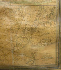 |
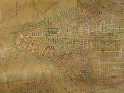
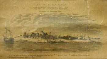
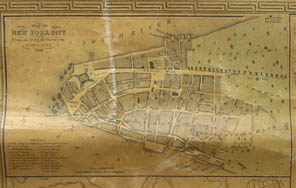
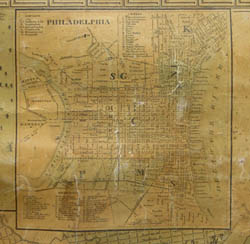
Map of New York City, including Manhattan and portions of present day Brooklyn as well as Jersey City, New Jersey. In 1833, J.H. Colton & Co. published their first map of the city “drawn by David H. Burr from the latest surveys.” This 1853 map follows the general composition of the one published 20 years earlier, with a different border and the addition of detailed mapping of the areas surrounding Manhattan, as well as inset maps of Philadelphia, Boston, “North or Hudson River,” and “Vicinity of New York Showing the Principal Roads, Rail-Roads and Canals with distance of Villas from the City.” Two other historical insets demonstrate the growth of the city: the “Map of New York City from an actual Survey by James Lyne 1728” and an engraved view of the colony of New Amsterdam as seen from Governors Island, erroneously attributed to “Doctor Adrien van der Dunk.”
This engraving, known today as the Visscher View, also was included on Colton’s 1833 map. Its authorship is unknown. Adriaen van der Donck was the leader of a group of New Amsterdam residents who crossed the Atlantic to lodge a protest with the Dutch government concerning the mismanagement of the colony by the Dutch West India Company. They brought with them a map that was probably the manuscript prototype for the Jansson-Visscher Map, a strikingly accurate and detailed map of New Amsterdam which was first published around 1650 by Johannes Jansson in the Netherlands. In 1655, the Dutch publisher Nicolaus Janszen Visscher (a.k.a. Claes Jansoon Visscher, 1618-1679) published a version of the map that included the Visscher View. The Jansson-Visscher Map became a best seller and was reissued for roughly the next 100 years.
An earlier version of this map, from 1849 and in three sheets with no rollers, is in the collection of the New York Public Library.
Between 1831 and 1890, the Colton firm dominated American map publishing and their atlases were the finest produced in the U.S. during the 19th century. The company was founded by Joseph Hutchins Colton (1800-1893), who had no formal training in geography or cartography; he began by purchasing copyrights of maps prepared by other individuals or companies, and his principal role was to manage the production and distribution of the maps. His first maps were drawn by the esteemed cartographer David H. Burr in the 1830s. By the 1850s Colton was also publishing guidebooks, atlases and immigrant and railroad maps. The firm was renamed G.W. & C.B. Colton in the 1860s when Colton was succeeded by his sons -- George Woolworth Colton (1827-1901) and Charles B. Colton (c. 1831-1916). It is believed that George Colton compiled the company's 1855 Atlas of the World and served thereafter as the firm's principal map compiler, cartographer and engraver.
Joseph H. Colton sold his atlas plates to Alvin Jewett (A.J.) Johnson in 1860. Johnson, the publisher, is best known for his atlases, issued in many editions in the second half of the 19th century, beginning with the publication of Johnson's New Illustrated (Steel Plate) Family Atlas. In 1898, the G.W. & C.B. Colton firm became Colton, Ohman & Co. and published under that name until about 1901, when August R. Ohman began publishing under his own name as "successor to the Coltons."
References:
“CATNYP. Call # Map Div. 00-14508.” The New York Public Library. http://catnyp.nypl.org/search~/c?SEARCH=Map+Div.+00-14508+ (11 August 2004).
Cohen, Paul E. and Augustyn, Robert T. Manhattan in Maps: 1527-1995. New York: Rizzoli, 1997. pp. 32, 120-121.
Ristow, Walter W. American Maps & Mapmakers: Commercial Cartography in the 19th century. Detroit, MI: Wayne State University Press, 1985. pp. 316-318, 325, 327.