
Colton: 1889
This item is sold. It has been placed here in our online archives as a service for researchers and collectors.
- Please inquire as to the availability of similar items currently in stock, or use the navigation bar above to browse our site for currently available items.
- Find guidelines for the use of images from georgeglazer.com.
- To see more archived items, view our directory.
- Find information about selling your art and antiques.

|
Map of the Country Thirty Three Miles Around |
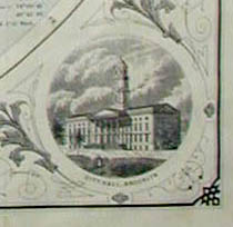 |
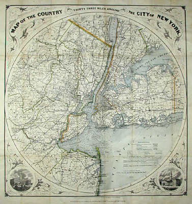
Interesting circular map of the New York City metropolitan area at the turn of the century. Includes New York City, Parts of Westchester, Rockland, New Jersey. Table of explanations indicates Counties, Townships, Cities, Post Offices, Settlements and Neighborhoods, Roads, Canals, Telegraph lines, Mills and Factories, Railroads, and Projected Railroads. Roadways also have distances in miles. Water depth in harbor indicated. Vignette views of the city halls of New York and Brooklyn in each of the bottom spandrels, together with Aesthetic Movement foliate design in all four spandrels.
Between 1831 and 1890, the Colton firm dominated American map publishing and their atlases were the finest produced in the U.S. during the 19th century. The company was founded by Joseph Hutchins Colton (1800-1893), who had no formal training in geography or cartography; he began by purchasing copyrights of maps prepared by other individuals or companies, and his principal role was to manage the production and distribution of the maps. His first maps were drawn by the esteemed cartographer David H. Burr in the 1830s. By the 1850s Colton was also publishing guidebooks, atlases and immigrant and railroad maps. The firm was renamed G.W. & C.B. Colton in the 1860s when Colton was succeeded by his sons -- George Woolworth Colton (1827-1901) and Charles B. Colton (c. 1831-1916). It is believed that George Colton compiled the company's 1855 Atlas of the World and served thereafter as the firm's principal map compiler, cartographer and engraver.
Joseph H. Colton sold his atlas plates to Alvin Jewett (A.J.) Johnson in 1860. Johnson, the publisher, is best known for his atlases, issued in many editions in the second half of the 19th century, beginning with the publication of Johnson's New Illustrated (Steel Plate) Family Atlas. In 1898, the G.W. & C.B. Colton firm became Colton, Ohman & Co. and published under that name until about 1901, when August R. Ohman began publishing under his own name as "successor to the Coltons."
Full publication information: G.W. & C.B. Colton & Co., 182 William Street, New York.
References:
Cohen, Paul E. and Augustyn, Robert T. Manhattan in Maps: 1527-1995. New York: Rizzoli, 1997. p. 120.
Ristow, Walter W. American Maps & Mapmakers: Commercial Cartography in the 19th Century. Detroit, MI: Wayne State University Press, 1985. pp. 325, 327.