Phelps' Illustrated Guide to the Central Park
Gaylord Watson, No. 16 Beekman St., New York (publisher)
Humphrey Phelps, New York: 1865 (copyright)
17.5 x 23 inches, overall
Hand-colored lithograph
Sold, please inquire as to the availability of similar items.

Illustrated Guide to Central Park
Humphrey Phelps, 1865
Humphrey Phelps, 1865
This item is sold. It has been placed here in our online archives as a service for researchers and collectors.
- Please inquire as to the availability of similar items currently in stock, or use the navigation bar above to browse our site for currently available items.
- Find guidelines for the use of images from georgeglazer.com.
- To see more archived items, view our directory.
- Find information about selling your art and antiques.
 |
 |
 |
 |
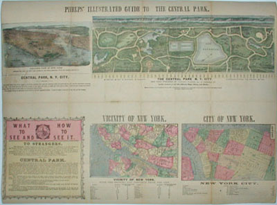
Scarce ephemeral composite broadsheet with maps, views and broadside relating to Central Park and New York City, dated 1865, when the park had recently been extensively developed and landscaped. It was published by Phelps, which issued a series of folding maps and wall maps for travelers in the 19th century. Originally it was included in a guidebook published by Gaylord Watson called The Great Metropolis. Phelp’s New York City Guide, copyrighted 1865 and issued as a revised edition in 1870.
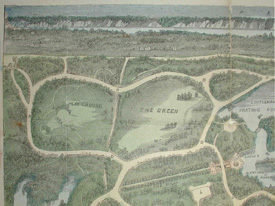
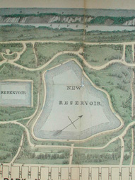
In the upper right a large map of Central Park entitled "The Central Park, N. Y. City," shows, from south to north, Playground, The Green, Gentleman's Skating Pond/ Ladie's [sic] Skating Pond, Old Reservoir, and New Reservoir. A key indicates Bridge Road , Drive, Flower Garden, Carriage Circle, Standing place for Carriages, Traffic Roads and Walks. The Hudson River and New Jersey Palisades are shown in the distance.
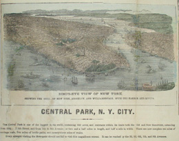
A "Bird's-Eye View of New York," upper left, shows Manhattan surrounded by Hudson and East Rivers, with Brooklyn and Long Island in distance.
A map of the "City of New York," lower right, shows lower Manhattan, together with a key of statistics such as population (1,000,000) and number of savings banks (25).
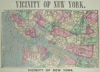
A map of the "Vicinity of New York," lower center, shows the New York metropolitan areas, including the boroughs, and parts of Westchester County and New Jersey.
Lower left is a lengthy text titled "What to See and How to See It:"
TO STRANGERS. This Metropolis, whether regarded as the home of 1,000,000 of inhabitants, or as the richest in the Western World, naturally a place to which the attention of strangers is strongly directed.
A visit to New York is among the things which nearly every person in the country tries to accomplish at least once in a lifetime; and travelers from other countries are every year showing an increasing tendency to become acquainted with the Empire City of the Republic.
What London is to England, or Paris is to France, New York is to America.
CENTRAL PARK. This magnificent Park is bounded by 5th and 8th Avenues, and 59th and 110th Streets - 843 Acres. The old Croton reservoir, containing 35 acres, and the new reservoir, containing 106 acres (elevated 115 feet above tide-water), as well as the following ponds, are located within its limits: The pond near 59th Street, containing 4 acres; the lake between 72nd and 78th Streets, containing 20 acres; the pool near 8th Avenue of 2 acres; and the Lock and Harlem Lake, estimated at 14 acres; and 8 acres occupied by 4 traverse roads. It is not yet completed, but is already the most extensive public park on this continent; citizens and strangers duly appreciate the ample and increasing attraction of this common pleasure ground. Fowls, Animals, and rare plants, in great variety, have been received from almost every clime [sic.]. The old Arsenal is now occupied for the Park Offices and as a Museum, in which are found rare specimens of Statuary and Bass-reliefs. Every visitor should spend an hour at this building. The following are some of its principal drives and walks:
First. A principal road or drive, which, in its entire extent, embraces every feature of importance within its limits. This drive is sufficiently wide to admit of its being used by several vehicles at the same time, and is long enough for an afternoon drive.
Second. Another drive, secluded in its character, used by such persons as desire to be more retired.
Third. Certain roads devoted to equestrians, to the exclusion of vehicles.
Fourth. Certain walks devoted exclusively to pedestrians.
Fifth. Certain transverse roads at convenient distances, to allow of an easy transit across the Park for business and other purposes.
Sixth. Spaces devoted to Botanical and Horticultural purposes.
Carriages are in waiting at several of the entrances to convey persons over its grounds. In Winter tens of thousands of skaters are enjoying themselves upon its beautiful Lakes, and in Summer the splendid boats gliding upon its waters are liberally patronized.
The map is a combined production of Humphrey Phelps and Gaylord Watson. Gaylord Watson was a map chart and print publisher, established in New York City in 1828. They also published a general tourist guide to New York City with fold out map accompanied by text in hard covers entitled The Great Metropolis New York City Guide.
The lithography firm of Humphrey Phelps (also known as Phelps, Humphrey) operated in New York City from 1841 to 1853, and at various times co-publishing work with Ensigns & Thayer. They produced maps, prints and books, and are known for the "Phelps Guides" series of folding maps and wall maps for travelers, which Phelps began producing in 1838.
Reference:
Deák, Gloria Gilda. Picturing America 1497-1899, Vol. 1. Princeton , New Jersey : Princeton University Press, 1988. pp. 535-537.