George Eldridge (1812-1900) (hydrographer)
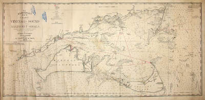
No. 1. Eldridge’s New Chart of Vineyard Sound and Nantucket Shoals
S. Thaxter & Son, Boston: 1900 (copyright 1894)
Black-and white engraving, backed on linen, as issued
22.5 x 47.5 inches, border
24.75 x 49.5 inches, overall
Sold, please inquire as to the availability of similar items.

Chart of Vineyard Sound and Nantucket Shoals
Eldridge Antique Sea Chart
Eldridge Antique Sea Chart
This item is sold. It has been placed here in our online archives as a service for researchers and collectors.
- Please inquire as to the availability of similar items currently in stock, or use the navigation bar above to browse our site for currently available items.
- Find guidelines for the use of images from georgeglazer.com.
- To see more archived items, view our directory.
- Find information about selling your art and antiques.
 |
 |
 |
 |
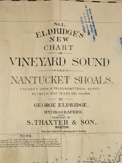 |
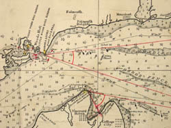
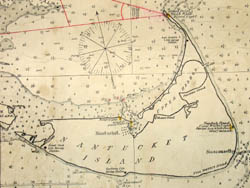
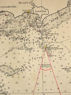
Large and impressive turn-of-the century navigational chart of Vineyard Sound in the Atlantic Ocean, based on surveys from 1851-99. It includes Martha’s Vineyard and Nantucket Island, and the coast along Cape Cod from Woods Hole, Hyannis, Harwichport, and Chatham to Crab Ledge Fishing Ground. As was typical at the time this was published, the chart was backed on linen for ease of use and storage at sea.
Buoys are indicated with different symbols to indicate red, black, horizontal or perpendicular stripes, whistlers and bells. Symbols, lines and shading on the map indicate sunken rocks, shoals, currents, fathoms, and sailing lines. Sounds are expressed in feet. Lighthouses are depicted in yellow with red radial lines showing the areas in which the light beams flash red.
George Eldridge was a hydrographer, credited with making the first charts of the Atlantic Coast. Hydrographers measure, describe and map surface waters with special reference to navigation. Eldridge's charts were published from 1867 through the early 20th century. Some were separately issued -- generally large rolled charts backed on linen or blue paper (so called blue backs) and others were published in a smaller format in atlas editions of the Eldridge Tide and Pilot Book and the Book of Harbor Charts.
S. Thaxter & Son advertised themselves as "Dealers in Nautical Instruments, Charts, Nautical Books, &c." Samuel Thaxter (1769-1842) founded the company in Boston in 1792 shortly thereafter moved to State Street. From 1822 until 1919 the firm operated as S. Thaxter & Son.
The chart is stamped by the vendor, Steamer Susie D., a water boat that was owned by Captain William M Randall (1853-1914). Around 1893, Randall began operating the Susie D., which ran mail up and down the coast and sold supplies to boats passing through Vineyard Sound. He retired and sold the boat in 1908.
Two large Eldridge Chart paper labels are on the reverse side.
Blue ink stamps: SOLD FROM/ Steamer Susie D./ Water, Charts, Provisions &c./ VINEYARD HAVEN, MASS.
References:
Baer, Chris. "Main Street, Vineyard Haven, MA. North of the Bank: Capt. and Mrs. Randall's Home (1900 - 1923)." Historical Records of Tisbury, Massachusetts. http://history.vineyard.net/mainst/zero/ (12 January 2006).
"Dry Card Compass." Smithsonian National Museum of American History Behring Center. http://americanhistory.si.edu/collections/navigation/object.cfm?recordnumber=1197892 (12 January 2006).
Ormond, Leonee. "'Captain's Courageous' Chapter V. Notes on the Text." 1995. Online at Captain's Courageous Reader's Guide. 25 June 2004. http://www.kipling.org.uk/rg_courageous_notes5.htm (12 January 2006).
"Thaxter." Smithsonian National Museum of American History Behring Center. http://americanhistory.si.edu/collections/navigation/maker.cfm?makerid=62 (12 January 2006).
"The People Behind the Names." U.S. Navy Armed Guard. http://www.armed-guard.com/pbtne.html (12 January 2006).