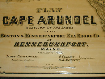
Cousens & W.S. Dennett (Civil Engineers and Surveyors)
James Cruickshanks, Landscape Gardener
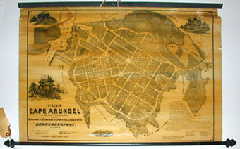
Plan of Cape Arundel/ A Section of the Lands of the Boston & Kennebunkport Sea Shore Co. at Kennebunkport, Maine.
J. Mayer & Co., Boston: February 15, 1873
Engraved map, varnished, backed on linen, mounted on rollers, as issued
22 x 30 inches
Sold, please inquire as to the availability of similar items.

Plan of Cape Arundel
Boston: 1873
Boston: 1873
This item is sold. It has been placed here in our online archives as a service for researchers and collectors.
- Please inquire as to the availability of similar items currently in stock, or use the navigation bar above to browse our site for currently available items.
- Find guidelines for the use of images from georgeglazer.com.
- To see more archived items, view our directory.
- Find information about selling your art and antiques.
    |
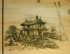 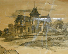  |
Rare decorative promotional map, issued by a railroad company, as a plan for proposed early development of Cape Arundel as a summer beach resort in the Kennebunkport, Maine, region. The map is directed to purchasers or renters of "cottage lots or hotel sites" and "boarding houses or cottages." According to promotional text:
The Boston and Kennebunkport Sea Shore Company's lands comprise most of the desirable property upon a water-front of more than five miles, and cover between six and seven hundred acres, adjoining the pleasant village of Kennebunkport. (This plan shows about 240 acres near the centre of the location.) ... It is of easy access, being only about three hours' ride from Boston, via Eastern or Boston and Maine R.R. ... [, can apply to [four names and addresses].
The industrial revolution entailed, among other things, the expansion of towns and cities, the continual reworking of urban infrastructures, and the increasing specialization of knowledge. Inevitably, there evolved several groups of professionals, each responsible for a particular portion of financing, building, and running the American city. And many of these groups made and used maps in support of their work. Property developers created "paper cities" to sell ambitious projects, some of which succeeded, but many of which remained imaginary.
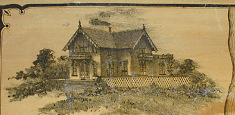
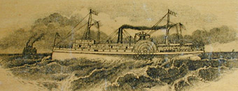
The map includes three engraved vignettes of buildings and an image of a steamship cruising Cousin's Cove. Considerable garden and landscape detail is shown, roads are labeled, lots numbered, hotel sites are identified. The coast shows Arundel Beach, The Old Fort, Spouting Rock, Murmuring Caverns, Cathedral Chair, Dragon's Cart Road, Pebble Beach, Maiden's Stairway, Bouncing Rock, Blowing Cave.
Reference:
"Worldly Treasures - A Fifth Anniversary Celebration." Osher Map Library, University of Southern Maine. 2000. http://www.usm.maine.edu/maps/exhibit7/sec4a.html (29 May 2003).