Johann Baptist Homann (1664-1724) (editor)
Johann Hubner (cartography)
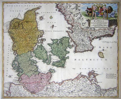
Regni Daniae in quo sunt Ducatus Holsatia et Slesvicum Insulæ Danicæ Provinciæ Iutia Scania Blekingia Nova Tabula
[Kingdom of Denmark in which are the Principalities Holsatia and Schleswig, Danish Isles, Provinces of Jütland, Sweden, Blekinge; New Plates]
J.B. Homann and Homann Heirs, Nuremberg and Amsterdam: 18th Century
20.5 x 24 inches, overall
19 x 22.75 inches, printed border
Sold, please inquire as to the availability of similar items.

Map of Denmark
Edited by Johann Baptist Homann
Edited by Johann Baptist Homann
This item is sold. It has been placed here in our online archives as a service for researchers and collectors.
- Please inquire as to the availability of similar items currently in stock, or use the navigation bar above to browse our site for currently available items.
- Find guidelines for the use of images from georgeglazer.com.
- To see more archived items, view our directory.
- Find information about selling your art and antiques.
 |
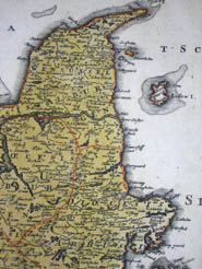 |
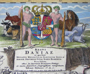
Map of the Kingdom of Denmark, also showing a portion of southern Sweden and the Baltic. Towns, counties, cities, rivers, and raised topography are all depicted. The decorative cartouche shows two semi-nude men with large clubs holding the coat of arms of Denmark, before a backdrop of seated and standing livestock and a blue sky . A distance scale in the lower right appears is given in three different systems of measurement.
Inscription: Io. Baptista Homanno – Noribergæ. Et aucta secundum Geographium novissimam Iohann Hubneri J.U.L. [Johann Baptist Homann -- Nuremberg. And additional new geography after Johann Hubner J.U.L.]
Johann Baptist Homann, a former Dominican monk, became a celebrated cartographer of 18th century Nuremburg, Germany, producing maps and celestial charts (generally in atlases), and globes of high quality both in their geographic accuracy and aesthetic appeal. According to map expert R.V. Tooley: "The most important and prolific map-makers in Germany in the 18th century were the Homann family (1702-1813). The founder and principal member was Johann Baptist Homann. He set up his headquarters in Nuremberg and quickly dominated the German market. Nor did he confine his efforts to his homeland, but produced general atlases covering the whole world."
After settling in Nuremburg in 1688, Johann Baptist Homann was employed as a map engraver before founding his own firm in 1702. Homann’s geographical, celestial, and astronomical maps were published in a variety of states throughout the 18th century, which are generally difficult to distinguish from one another. Most of his geographical maps first appeared in Atlas Novus [New Atlas] (1714) and his celestial maps, produced in collaboration with Johann Gabriel Doppelmayr, were issued as part of various publications before being published as a collection posthumously by his heirs, most notably as Atlas Coelestis in quo Mundus Spectabilis et in Eodem Stellarum Omnium Phoenomena Notabilia, issued as 30 plates in 1742.
Homann’s geographical maps were frequently republished by the Homann heirs throughout the 18th century, most notably in Atlas Geographicus Maior (c. 1780) and Atlas Homannianus, (Amsterdam, 1731-1796). Homann was initially succeeded by his son, Johann Christoph Homann (1703-1730), then by his friend Johann Michael Franz (1700-1761) and stepsister’s husband Johann Georg Ebersberger (1695-1760). The company continued operations under different names until 1848.
References:
Dekker, Elly, et al. Globes at Greenwich: A Catalogue of the Globes and Armillary Spheres in the National Maritime Museum, Greenwich. London: Oxford University Press and the National Maritime Museum, 1999. p. 327.
Tooley, R.V., Maps and Map-Makers. New York: Bonanza Books, 1949. p. 27.
van Gent, Robert Harry. “The Atlas Coelestis (1742) of Johann Gabriel Doppelmayr.” 23 April 2003. http://www.phys.uu.nl/~vgent/doppelmayr/doppelmayr.htm (15 September 2004).