Louis-Charles Desnos (1725-1791?)
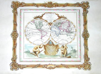
Mappe-Monde [World Map]
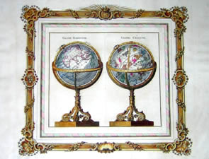
Globe Terrestre, Globe Céleste [Terrestrial Globe, Celestial Globe]
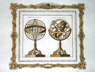
Sphère de Copernic, Sphere de Ptolemée [Copernican Sphere, Ptolemaic Sphere]
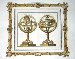
Sphère Droite, Sphère Parallele [Right Sphere, Parallel Sphere]
from Atlas Général Methodique
Paris: 1768
Hand-colored engravings
15.25 x 20 inches, average approximate overall
13.75 x 16.25 inches, average approximate plate mark
Sold, please inquire as to the availability of similar items.

Atlas Général Methodique
Louis-Charles Desnos, 1768
Louis-Charles Desnos, 1768
This item is sold. It has been placed here in our online archives as a service for researchers and collectors.
- Please inquire as to the availability of similar items currently in stock, or use the navigation bar above to browse our site for currently available items.
- Find guidelines for the use of images from georgeglazer.com.
- To see more archived items, view our directory.
- Find information about selling your art and antiques.
 |
 |
 |
Set of four prints, by the acclaimed French map publisher and globe maker of the Louis XVI period, Louis-Charles Desnos. The set is comprised of a double hemisphere world map, a print of a terrestrial and celestial globe, and two prints of armillary spheres. The globe and armillaries are all set on bronze rococo stands and the prints each set within a bronzed rococo frame border.
Mappe-Monde
Cartouche: “Dressée pour l’Etude de la Géographie, rélativement aux Auteurs les plus Modernes. Revûë, corrigée et augmentée d’après les Nouvelles Observations Astronomiques de Mrs. Tchirikcow et de l’Isle. Revuë de nouveau par M. Brion Ingenieur Geogr.’ Du Roy.” [Drawn up for the study of geography, according to the most modern authors. Revised, corrected and augmented after the new astronomical observations of Messieurs Tchirikcow and of de l’Isle. Newly revised by Monsieur Brion, Geographical Engineer of the King.]
Dedication: “Dédiée au Roy Par Sou très humble et très obeissant servituer et fidel sujet Desnos, Ingénieur Géographe pour les Glóbes et Sphères. Rue S. Jacques à l’Enseigne du Glòbe, où l’on trouve généralement tout ce que concerne les Sciences. 1766. A.P.D.R.” [Dedicated to the King by his very humble and very obedient servant and loyal subject Desnos, Geographical Engineer for Globes and Spheres. St. Jacques Street at the Sign of the Globe, where one can find everything concerning the sciences. 1766. A.P.D.R.]
Double hemisphere world map supported by two Atlas (or Hercules) figures holding a dedication banner. Continents outlined in green and red. Unusual cartographic aspects are oddly shaped Alaskan and Australian coasts, based on the incomplete information available at the time, and a large body of water in northwestern North America called “Mer de l’Ouest” [Sea of the West]. During the 18th century, the French and the British were searching for a passage around or through the North American continent, which would expedite ship travel between the Atlantic and Pacific Oceans. French and British explorers traveled by land and by sea in search of the Sea of the West, a body of water which they believed lay between the Rocky Mountains and the Pacific and which would constitute part of an inland waterway connecting the Pacific to the Atlantic or Arctic Ocean. Its existence was finally disproved by the voyages of the English explorers George Vancouver and Alexander Mackenzie along the Northwest Pacific Coast between 1792 and 1794.
The dedication on the cartouche for the Mappe-Monde indicates that Desnos based the cartography in part on astronomical observations of De l’Isle. That reference perhaps is to the famous astronomer Joseph Nicolas De l’Isle, who was in charge of the Royal Observatory in St. Petersburg, Russia, where he lived for 22 years, returning to France in 1747. However, it could also be related to his brothers Guillaume and Nicolas De l’Isle, both prominent geographers.
Desnos credits the revisions of the map to Louis Brion de la Tour (fl. 1756-1823), who also collaborated with him on other maps. Little is known about Brion de la Tour except that he held the post of Ingenieur-Geographe du Roi and published a wide range of statistical works and many atlases.
Globe Terrestre, Globe Céleste
Terrestrial and celestial globe pair shown side by side. The globe is set showing Europe and Asia. The celestial shows the constellations as interpreted by classical mythology, including the zodiac band.
Sphère de Copernic, Sphère de Ptolemée
A Copernican and Ptolemaic armillary sphere are depicted together.
Sphère Droite, Sphère Parallele
Ptolemaic armillary sphere shown in two different positions, one in the usual upright orientation and the other on its side with axis points at the horizon.
Louis-Charles Desnos entered the map and globe business in the 1750s as a “fondeur” or instrument maker, when he married the widow of French globe maker Nicolas Hardy (before 1717-1744). Nicolas had inherited the business founded by his father Jacques Hardy (fl. 1738-1745), including the globes, spheres, copper plates and tools. Desnos was one of four French globe makers at the time, and became one of the most successful map and atlas publishers of the Enlightenment, later exchanging the title of fondeur for the more prestigious “ingenieur géographe” (geographic engineer) as well as “marchand libraire” (bookseller). He is known to have collaborated with the geographer Jean-Baptiste Nolin.
References:
Dahl, Edward H. and Gauvin, Jean-François. Sphaerae Mundi: Early Globes at the Stewart Museum. Canada: Septentrion and McGill-Queen's University Press, 2000. p. 150. (re: Desnos)
Dekker, Elly, et al. Globes at Greenwich: A Catalogue of the Globes and Armillary Spheres in the National Maritime Museum, Greenwich. London: Oxford University Press and the National Maritime Museum, 1999. p. 352. (re: Desnos)
Dekker, Elly and van der Krogt, Peter. Globes from the Western World. London: Zwemmer, 1993. pp. 70, 74. (re: Desnos)
Dooley, R.V. Maps and Map-Makers. 4th Ed. New York: Bonanza Books, 1970. p. 44. (re: De l’Isle and Desnos).
"Présence française en Amerique du Nord: La mer de lOuest, un lieu à découvrir depuis les tout premiers débuts." Archives Nationales Québec. 25 March 2004. http://www.anq.gouv.qc.ca/conservation/instruire/cartes/explo_1.htm (18 June 2004).