Thaddeus Mortimer (T.M.) Fowler (1842-1922) (after)
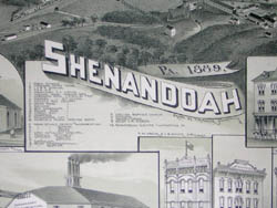
Shenandoah PA., 1889
T. M. Fowler & J. B. Moyer, Morrisville, Pennsylvania: 1889
Tinted lithograph
24 x 29.75 inches, overall
20.75 x 27.5 inches, image
Sold, please inquire as to the availability of similar items.

Shenandoah, Pennsylvania
Bird's Eye View, 1889
Bird's Eye View, 1889
This item is sold. It has been placed here in our online archives as a service for researchers and collectors.
- Please inquire as to the availability of similar items currently in stock, or use the navigation bar above to browse our site for currently available items.
- Find guidelines for the use of images from georgeglazer.com.
- To see more archived items, view our directory.
- Find information about selling your art and antiques.
 |
 |
 |
 |
 |
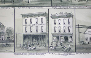 |
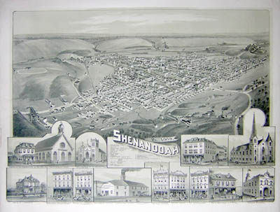
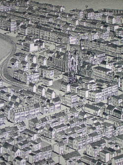
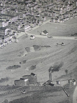
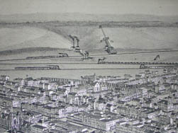
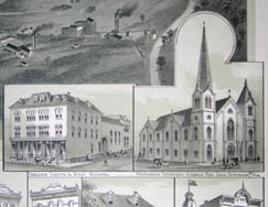
Bird’s-eye-view of Shenandoah, a town in Eastern Pennsylvania, showing various buildings, streets and railroads in topographical perspective, together with horse drawn carriages and pedestrians. Thirteen additional larger images of notable buildings appear in the lower margin, including the Church of the Annunciation, Trinity Reformed Church, Ferguson Theatre & Bank, Methodist Episcopal Church, the Watson House, and the Shenandoah Electric Illuminating Company. A key next to the title provides information corresponding to various buildings numbered throughout the view including public schools, Ferguson’s Opera House, rail road stations, collieries, and churches. Another print from this edition is in the collection of the Library of Congress.
The period from after the Civil War to about 1910 was the heyday of promotional bird’s-eye views of American towns. Historians estimate that approximately 4,500 different ones were produced nationwide during this period. In an era before aviation, the creation of these panoramic maps was an act of imagination, combining information from city maps, ground-level sketches of buildings and the rules of Renaissance perspective into a convincing aerial view. Some were commissioned to promote settlement and development of towns, especially as part of the Westward Expansion of the United States. They were also purchased by residents as emblems of civic pride. American bird’s-eye views were largely supplanted by aerial photographs in the 20th century. Few records remain of the size of the press runs for panoramic maps, but it has been surmised that they were perhaps as few as 100 for a small town, though a typical edition was about 500 copies. Given these small editions and their ephemeral nature, many are now quite scarce.
Thaddeus M. Fowler was a leading artist and lithographer of views, during the heyday of promotional bird’s-eye views of American towns, just after the Civil War to the turn of the century. His work is admired for its precise renderings and attention to cartographic and historical detail. He is likely the most prolific of all the American view makers, with over 400 to his credit during a 54-year career. Fowler’s output included 220 separate views of 199 towns in Pennsylvania, as well as locations in at least 21 states and three Canadian provinces. To put this figure in context, he was responsible for over 10% of the 1,726 panoramic maps recorded in a checklist produced by the Library of Congress in 1984. Perhaps the largest collection of Fowler views belongs to the Library of Congress, which has over 200, with another major collection in the library of the Pennsylvania State University Library, University Park.
Fowler was a colorful figure who ran away from home at age 15, and at 17 convinced military authorities to let him join the Union Army. Wounded in battle, he was discharged, and showed his entrepreneurial proclivity by traveling between army camps taking photographs of soldiers for them to send home. Fowler began his career as a producer of town views in 1868 as a subscription agent for panoramic mapmaker Albert Ruger, traveling throughout the nation sketching towns for prints. Later he established his own business and crisscrossed the U.S. and Canada, drumming up business and making the drawings for panoramic maps. Eventually he integrated photography into his working process. Fowler worked either independently or with various co-publishers, including O.H. Bailey, a Boston printer (operating as Fowler & Bailey), Thomas J. Bulger (as Fowler & Bulger) and James B. Moyer in Pennsylvania (as Fowler & Moyer). He died at age 80 after falling on an icy street while preparing a view of Middletown, New York.
References:
"American Panoramic Artists and Publishers." Library of Congress. 20 June 1997. http://lcweb2.loc.gov/ammem/pmhtml/panart.html#AR (22 February 2012).
Deák, Gloria Gilda. Picturing America. Princeton University Press: 1989. Items 847, 863 and 878.
Hébert, John R., ed., rev. by Patrick E. Dempsey. Panoramic Maps of Cities in the United States and Canada. 2nd ed. Washington, D.C.: Library of Congress, 1984. pp. 5-8.
Reps, John William. Views and Viewmakers of Urban America: Lithographs of Towns and Cities in the United States and Canada, 1825-1925. p. 177. Online at Google Books: http://books.google.com/books?id=3mI1wvk_o3cC&dq (15 February 2012).
Wise, Donald A. “Bird’s-Eye Views of Oklahoma Towns.” Originally published in The Chronicles of Oklahoma, vol. 67, no. 3 (Fall 1989): 228- 247. Online Compilation of Historical Documents by Don Wise. 4 June 1998. http://home.earthlink.net/~dawise/view.htm (7 December 2004).