S. Cooke (engraver)
Wallis's Complete Voyage Round the World: A New Geographical Pastime
John Wallis, London: January 20, 1796
Two hand-colored engravings, folding, dissected and backed on linen
Marbleized pasteboard case, paste on oval title plate, 7 x 6.5 inches
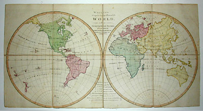
13.25 x 25 inches, game map
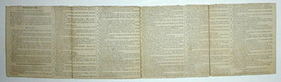
6.75 x 25 inches, instructions
Sold, please inquire as to the availability of similar items.

Wallis's Complete Voyage Round the World
J. Wallis, London: 1796
J. Wallis, London: 1796
This item is sold. It has been placed here in our online archives as a service for researchers and collectors.
- Please inquire as to the availability of similar items currently in stock, or use the navigation bar above to browse our site for currently available items.
- Find guidelines for the use of images from georgeglazer.com.
- To see more archived items, view our directory.
- Find information about selling your art and antiques.
 |
 |
Folding world map educational geography game comprised of double hemispheric map of the world to be used as a game board together with instructions (directions, rules, and geographical descriptions). Counters, pyramids, and totum were to be purchased separately, not included. 100 locations of the world used in the game are numbered on the map, the instructions giving a brief description of each location (countries, islands, cities, rivers, bodies of water, etc.) and what to do when a game piece lands there.
Directions: "Two or three persons may amuse themselves with this agreeable pastime, and if a double set of Counters and Pyramids are purchased, six may play at it. The Totum must be figured 1 to 8 on its several faces, with pen and ink. The pyramids are supposed to be the travelers who make the tour; each pyramid having 4 counters of the same colour belonging to it, which are called markers or servants; when you find these are complete, you may begin the game agreeable to the following."
John Wallis (d. 1818) was a London game, book, map and print maker and seller, operating from 1775, when his business was called the Map Warehouse. In 1805, he opened the Instructive Toy Warehouse. He published music imprints, maps by John Cary, and children’s material, co-operating with the Newberys and various provincial retailers. With his son Edward, who joined the business in 1813, he also operated Wallis’s, a circulating library and reading room. Together they published under the imprint Wallis and Son or John & Edward Wallis. Edward succeeded his father and published under his own name until about 1847, at which time the Wallis stock was taken over by J. Passmore. John Wallis’ son, John Jr. (b. 1780) was also involved in publishing. After an apprenticeship to his father, he worked for the London Stationers’ Company and briefly operated his own London firm. He then relocated to the coastal resort of Sidmouth, where he established his own circulating library and reading room, the Marine Library, and published aquatints, lithographs and illustrated books, many focusing on the Devon region.
The Wallis family (John Sr. and Edward) produced pictorial maps as well as cartographic and historical jigsaw puzzles and folding board games. John Wallis Sr. published London and Westminster in the Reign of Queen Elizabeth Anno Dom. 1563 (1789) a pictorial map of London from a historical perspective and Wallis's Complete Voyage Round the World: A New Geographical Pastime (1796). Edward Wallis published a Picturesque Round Game of the Produce & Manufactures, of the Counties of England & Wales (c. 1826-1837) and a similar game map of the Eastern United States, Game Of The Star-Spangled Banner or Emigrants to the United States. Other Wallis family publications include A Tour through England, A Tour through Europe, A Tour Through Scotland and The Genealogy of the Kings of England; from Egbert 1st King to the Present Time.
Full publication information: S. Cooke, , 17 Ferter Lane, London. John Wallis, Map Warehouse, Ludgate-Street, London.
References:
“John Wallis (publisher).” Wikipedia. 24 January 2005. http://en.wikipedia.org/wiki/John_Wallis_(publisher) (28 April 2005).
Maxted, Ian. “Etched on Devon’s Memory. Publishers and engravers: the production of Devon topographical prints.” Devon Library and Information Services. 1 July 2004. http://www.devon.gov.uk/library/locstudy/etchpubl.html (28 April 2005).
Maxted, Ian. "The London book trades 1775-1800: a preliminary checklist of members." Exeter Working Papers in British Book Trade History. U.K.: Devon Library and Information Services. 20 June 2001. http://www.devon.gov.uk/library/locstudy/bookhist/lonw.html (25 March 2003).
Whitehouse, F.R.B. Table Games of Georgian and Victorian Days. Royston, Hertfordshire: Priory Press, 1951, p. 76 (listing Wallis catalog mentioning this game).