Jean-Baptiste Nolin (geographical engineer)
J.B. Poirson (cartographer)
Mappe-Monde Contenant Les Parties Connues Du Globe Terrestre [World Map Containing the Known Parts of the Terrestrial Globe]
Chez Jean, Rue Jean de Beauvais No. 10, Paris: 1814
Hand-colored engraving, mounted on linen
31 x 42 inches
Sold, please inquire as to the availability of similar items.

Mappe - Monde
Original French Design, Early 19th Century
Original French Design, Early 19th Century
This item is sold. It has been placed here in our online archives as a service for researchers and collectors.
- Please inquire as to the availability of similar items currently in stock, or use the navigation bar above to browse our site for currently available items.
- Find guidelines for the use of images from georgeglazer.com.
- To see more archived items, view our directory.
- Find information about selling your art and antiques.
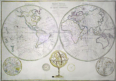
Large double hemisphere map of the world updated at the end of the Napoleonic era in France in 1814, by J.B. Poirson, from an earlier map by J.B. Nolin (elder or younger). Translated, the title is "Map of the World Containing the Known Parts of the Globe Drawn up According to Earlier Observations by J.B. Nolin, Geographical Engineer, Re-examined and Corrected by J.B. Poirson in the Year 1814."
The hemispheres are labeled "Hemisphere Occidental au Nouveau Monde decouvert en 1492" meaning "Western Hemisphere in the New World discovered in 1492," and "Hemisphere Oriental seul connu des Anciens," meaning "Eastern Hemisphere Known by the Ancients." The map is very detailed showing numerous place names, and highlighted by outline colors. Tracks of explorers such as Cook, Fourneau, Tasman are indicated.
Beneath the world map is "Sphere Armillaire Oblique" an armillary sphere showing the geocentric theory of the universe of the ancient geographer Ptolemy. The armillary is flanked by two round celestial charts showing the constellations of the northern and southern skies as interpreted with classical mythological figures, and with later named constellations in the form of scientific instruments. It is also flanked by two small astronomical charts of the solar system.
Jean-Baptiste Nolin (1657-1725) and his son, also named Jean-Baptiste (d. 1762), were renowned French cartographers. In 1700, the elder issued a fine large wall map titled "Le Globe Terrestre Represente en Deux Plan-Hemispheres Dresse Sur Les Dernieres Observations" engraved on four joined sheets and comprised of twin hemispheres supported by two mythological figures. Around 1740, the younger Nolin issued a set of continental wall maps. An Atlas Général based on Nolin's work was published in 1783, with 44 maps and four plates. This map is apparently based on the work of the Nolin family, updated and revised at the end of the Napoleonic era by J.B. Poirson.
Jean-Baptiste Poirson was a French cartographer active between 1798 and 1820. He issued series of maps of France and of its colonies. The credits on his maps sometimes refer to him as an "engineer-geographer."
Jean was a publisher in Paris on the rue St. Jean de Beauvais. The firm appears in theBibliographe de France,a 19th-century registry of prints, from 1811 to 1838.