Herman Moll
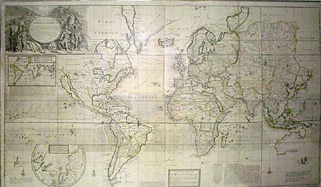
A New & Correct Map of the Whole World
Black and White Engraving, Outline Color
London: Early 18th Century
29 x 48 Inches
Sold, please inquire as to the availability of similar items.

A New & Correct Map of the Whole World
Moll, Early 18th Century
Moll, Early 18th Century
This item is sold. It has been placed here in our online archives as a service for researchers and collectors.
- Please inquire as to the availability of similar items currently in stock, or use the navigation bar above to browse our site for currently available items.
- Find guidelines for the use of images from georgeglazer.com.
- To see more archived items, view our directory.
- Find information about selling your art and antiques.
Herman Moll was an engraver of German descent, born about 1654, who set up a cartographic and publishing business in London in the late 1670s. His earliest known maps were executed for the geography book of Sir Jonas Moore published in 1683. Over the next fifty years he produced, as mapmaker and publisher, numerous works on classical, British and foreign geography, illustrated with maps of varying scales and detail in a distinctive clear style. At a time when French cartography, predominately through Guillaume De L'Isle, was at its most active and most far-reaching in territorial claims, Moll's maps with well-defined boundaries and numerous annotations achieved high acclaim. Moll's own statements regarding the inaccuracy of the maps of other cartographers, and the correctness of his own, appear in several instances. Even Jonathan Swift is said to have utilized Moll's maps for selecting accurate locations for incidents in Gulliver's Travels.
Moll's best known works are the large maps which he produced for his World Described, first published separately, and as a volume from about 1715. The two world maps, one the largest to appear in atlas form to date, and maps of most other areas of Europe and the world, compared cartographically with the out-of-date plates, after Sanson and Jaillot, still being printed on the continent, and visually with simpler productions of De L'Isle. These maps, at a large scale, are clearly engraved, have numerous annotations, and often large vignettes scenes, inset plans and details, and elaborate and decorative titlepieces. With their decoration, annotations, and detail they provide an excellent summation of British knowledge of the areas shown in the early 1700s.
This fine map is the largest world map produced for an atlas. A large title cartouche includes portraits of noble figures representing the four continents, and Moses receiving the Commandments. There are inset maps of the North Pole and of the world showing lines of magnetic variation (after Halley), and among the various annotations is an advertisement by Moll extolling his latest publications and decrying the work of, in this instance, Moses Pitt. Cartographical features include California as an island, South America in the style of De L'Isle, the South Pacific after Tasman, and an exaggerated northern extension to Siberia with "Parts Unknown" in the vast area between there and North America.