Justus Danckerts
Nova Totius Terrarum Orbis Tabula
[New Map of the Entire World]
Justus Danckerts, Amsterdam: c. 1680
Hand-colored copper-plate engraving
18.75 x 21.75 inches, image
21.75 x 24.25 inches, overall
Sold, please inquire as to the availability of similar items.

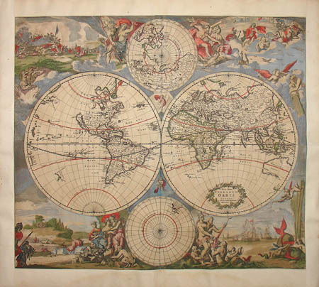
Double-Hemisphere World Map, c. 1680
Nova Totius Terrarum Orbis Tabula
Nova Totius Terrarum Orbis Tabula
This item is sold. It has been placed here in our online archives as a service for researchers and collectors.
- Please inquire as to the availability of similar items currently in stock, or use the navigation bar above to browse our site for currently available items.
- Find guidelines for the use of images from georgeglazer.com.
- To see more archived items, view our directory.
- Find information about selling your art and antiques.
Full map

Eastern hemisphere map |
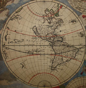
Western hemisphere map |
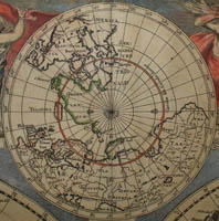
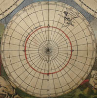
Northern polar map |
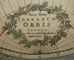
Cartouche |
Southern polar map |
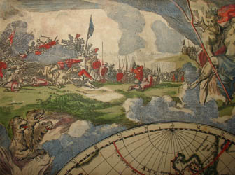
Detail of allegory of fire |
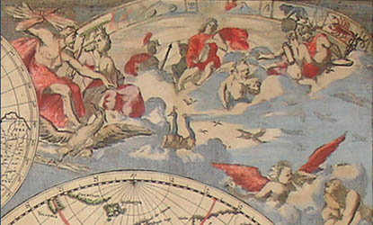
Detail of allegory of air |
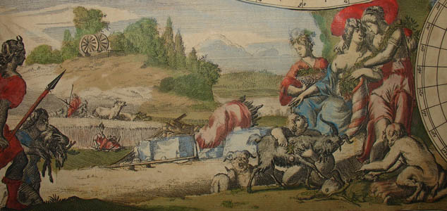
Detail of allegory of earth

Detail of allegory of water
Decorative double-hemisphere map of the world, set against a Baroque landscape decorated with intricate allegorical scenes mixing naturalism and figures from Greek mythology. Above and below the two large hemisphere maps are small inset polar maps, the North Pole showing Canada without the West Coast, and the South Pole devoid of geographical features except the southern tip of South America. Interesting geographical features of the hemisphere maps include the outline of Australia, called “Hollandia Nova” (New Holland); California shown as an island; and the northern portion of the North American Pacific Coast left blank.
Clockwise from the upper left corner, the illustrations represent the four elements: Fire with Pluto carrying off Persephone, attended by Cerberus, the three-headed guardian of Hades, as a battle scene rages in the background; Air as the heavenly realm ruled by Zeus and Hera, who are surrounded by winged creatures and other gods; Water with the sea god Neptune, mermen, a spouting whale, and sailing ships in the distance; and Earth represented by a scene with fauns presenting three goddesses with fruits of the harvest and livestock.
This is the first edition of Danckerts map (Shirley 495), in which both the geography and the decorative illustrations were adapted from Frederick De Wit's maritime world map of 1668 (Shirley 444). Danckerts produced a second edition, c. 1685, in which the hemispheres and poles were redrawn with numerous additional geographical details, and with a new cartouche noting that a privilege had been granted to the Danckerts firm (Shirley 529). Given the attractive decorative illustrations, it is not surprising that De Wit’s map widely influenced several other mapmakers as well; it was continuously adapted throughout the 18th century until at least 1802. This lengthy publishing history of the same basic map design by different firms was typical of how mapmakers operated in the 17th and 18th centuries.
Justus Danckerts (1635-1701) belonged to a mapmaking family, which included his father, his brother, and his three sons. He operated as a map publisher from the 1670s until his death. He generally did not date his atlases, and since one of his sons was also named Justus and pre-deceased him in 1692, it is uncertain which of them was the “Iusti Danckerts” named in the cartouche.
Cartouche: “Nova Totius Terrarum Orbis Tabula ex officina Iusti Danckerts, Amstelodami.”
Reference:
Shirley, Rodney W. The Mapping of the World:Early Printed World Maps 1472-1700. London: Holland Press, 1983. 444, 495, 529.