Paul Rapin de Thoyras (1661-1725) (editor and author)
Nicholas Tindal (translator)
Richard William Seale (d. 1785) (artist and engraver)
A Map of North America with the European Settlements & whatever else is remarkable in ye West Indies, from the latest and best Observations
from The History of England
John & Paul Knapton, London: 1744
Hand-colored engraving
14.5 x 18.25 inches, blue border
15.25 x 19 inches, platemark
15.75 x 19.5 inches, overall
Sold, please inquire as to the availability of similar items.

North America with the European Settlements
18th C. British Map Showing California as an Island
18th C. British Map Showing California as an Island
This item is sold. It has been placed here in our online archives as a service for researchers and collectors.
- Please inquire as to the availability of similar items currently in stock, or use the navigation bar above to browse our site for currently available items.
- Find guidelines for the use of images from georgeglazer.com.
- To see more archived items, view our directory.
- Find information about selling your art and antiques.

 California as an island |
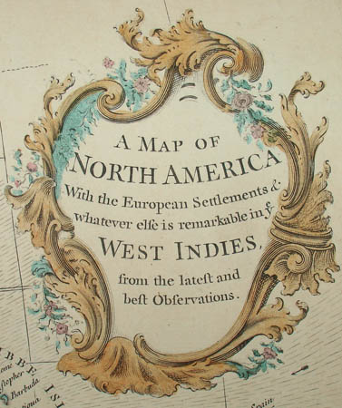 Cartouche |
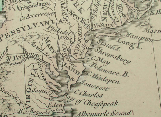
Detail of Eastern Seaboard
An 18th century British map of the North American continent decorated with an elaborate rococo cartouche. The map indicates routes of famous Caribbean explorers. It also features mountains shown as raised topography, and an explanation key shows symbols for “European Cities and Towns, Indian Towns, Forts and Castles.” Native American regions such as “Apaches de Navaio” are also shown. Shaded areas in waters marked with arrows indicate the trade winds.
This map was produced at a transitional point in terms of European understanding of the geography of the New World -- the Mississippi Valley, Mexico, the Great Lakes, and the Atlantic Coast are portrayed in detail with great accuracy. The northwestern portion of the continent, however, is labeled “Parts Unknown” and California is depicted as an island. Indeed, this map has the distinction of being one of the last to perpetuate that misinformation about California, which had influenced cartography for some 145 years. The story of California as an island began with a mistaken journal entry by a Spanish explorer in 1602, and even though some 100 years later another explorer concluded that California was attached to the continent, it took a royal edict by King Ferdinand VI of Spain to establish that as fact. In the meantime, many maps continued portraying it as an island, and here it is unusually large and distinct.
Paul Rapin de Thoyras was a French historian whose comprehensive Histoire d'Angleterre [History of England] was published in French in 1724-27 and updated and translated into English by Nicholas Tindal under the title Tindal's Continuation of Mr. Rapin’s History of England (1744). Tindal's version included 45 maps engraved by the London-based cartographer and engraver Richard William Seale. Seale also produced engravings for periodicals, books and atlases between 1732 and 1772.
The Knaptons were London booksellers in a family firm founded in 1736, trading under the name John & Paul Knapton from 1738 until Paul's death in 1755, whereupon John continued the firm under his own name until 1761.
References:
“1745 Map of North America Showing California as an Island.” Central Pacific Railroad Photographic History Museum. 2005. http://www.cprr.org/Museum/Maps/North_America_Map_1745.html (16 May 2006).
Maxted, Ian, ed. “The London book trades 1735-1775: a checklist of members.” Exeter Working Papers in Book History. 27 December 2008. http://bookhistory.blogspot.com/2007/01/london-1735-1775.html#K (6 December 2010).