E.B. O'Callaghan, ed.
America Septentionalist Pars. from the West-Indische Paskaert
from Documents Relative to the Colonial History of the State of New York
F. D'Avignon, New York: c. 1856
Hand-colored lithograph
18.5 x 21.5 inches, image
19 x 22.5 inches, sheet
29.5 x 34.5 inches, framed
Sold, please inquire as to the availability of similar items.

America Septentionalist
E. B. O'Callaghan, c. 1856
E. B. O'Callaghan, c. 1856
This item is sold. It has been placed here in our online archives as a service for researchers and collectors.
- Please inquire as to the availability of similar items currently in stock, or use the navigation bar above to browse our site for currently available items.
- Find guidelines for the use of images from georgeglazer.com.
- To see more archived items, view our directory.
- Find information about selling your art and antiques.
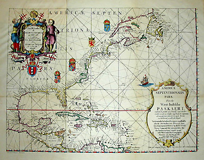
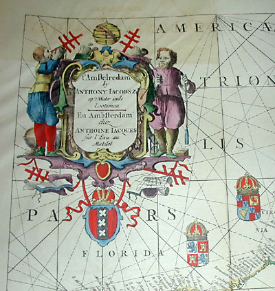

Print of manuscript map, dated 1621 "from the original on vellum in the collection of E.B. O'Callaghan, L.L.D." This Dutch sea chart of North America was first published by Anthony Jacobsz in 1621, and reprinted in this 19th Century American edition. It shows the east coast of North America from Canada down through Mexico into Central America and including the West Indies. Map locates cities, ports, shipping routes and islands. The sea is crisscrossed by rhumb lines and decorated with a sailing ship. Other decorations include coats of arms and two large ornate cartouches. The topmost cartouche is surmounted by an armillary sphere and incorporates two figures of navigators, at their feet, a globe, an hour glass, open books and charts.
This lithograph of the map is from O'Callaghan's Documents Relating to the Colonial History of New York, a 15-volume set published in 1856-57, an exceedingly important published source of early New York documents and manuscripts, many collected from foreign repositories, that covers the entire colonial period. According to the New York State Library, "Dr. O'Callaghan, an Albany physician and historian of New Netherland, compiled his monumental work largely from colonial manuscripts transferred to the State Library from the Office of the Secretary of State." The set remains of interest to historians and has been issued on CD.
Reference:
Yates, Melinda. "A Capital Asset: The History and Resources of the New York State Library." Capital Neighbors. Vol. 2, No. 4 and Vol. 3, No. 1 (Winter 1996 and Spring 1997). http://www.nysl.nysed.gov/library/otherpubs/capasset.htm (6 May 2002).