Jan Jansson (1596-1664) et al.
Mar del Nort [North Atlantic Ocean]
from Atlantis Majoris Quinta Pars, Orbem Maritimum
Jan Jansson, Amsterdam: c. 1650
Hand-colored engraving
17 x 22 inches, platemark
19.5 x 23.5 inches, overall
Sold, please inquire as to the availability of similar items.

Map of the North Atlantic & U.S. Coast
Jan Jansson, Amsterdam, c. 1650
Jan Jansson, Amsterdam, c. 1650

 |
 |
 |
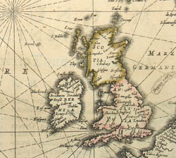 |
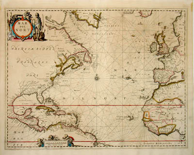
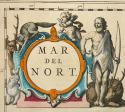
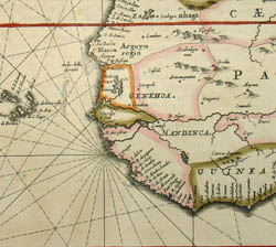
Maritime map of the North Atlantic, showing the East Coast of North America, Central America, the Gulf of Mexico, and the Caribbean to the west, and the British Isles, part of Western Europe, and part of West Africa to the east. Northeast of Canada is a large area labeled “Meta Incognita,” and the tips of Greenland and Iceland are also shown. The cartography is similar to earlier Hondius and Jansson maps, with some modifications, especially to the coastline of the present-day Mid-Atlantic and New England states. The map is crisscrossed by rhumb lines centered on a compass rose, and embellished with a decorative cartouche in the upper left of a male archer with a cupid and animals, and a smaller distance scale also decorated with figures. Mar del Nort was first published in 1650 as one of the 23 maps in Orbem Maritimum, the fifth volume of Jansson's Atlas Novus and the "first sea atlas in the real sense of the word ... a collection of charts in folio size, to serve as an atlas for general purposes" (Koeman).
Jan Jansson (Joannes Janssonius in Latin) was a contemporary and rival of the Dutch mapmaker Willem Janszoon Blaeu during the 17th century, when Amsterdam was a major European center for the production of maps. He produced maps of France and Italy in 1616 and an edition of Ptolemy’s Geography in 1617 and also constructed globes. Jansson married the sister of mapmaker Henry Hondius and with Hondius co-published the second volume of the Mercator-Hondius Atlas in 1633. Upon Hondius’ death around 1650, Jansson took over his business. Jansson published numerous other volumes of maps and atlases from 1638, including his reissue of Braun and Hogenberg’s Civitates Orbis Terrarum in 1657. His business was later acquired by Peter Schenk, who republished his major atlas about 1683.
References:
Burden, Philip D. The Mapping of North America: A List of Printed Maps 1511-1670. Herts, England: Raleigh Publications, 1996. Item 290.
Koeman, C. Atlantes Neerlandici. Bibliography of terrestrial, maritime and celestial atlases and pilot books published in the Netherlands up to 1880. Volume II, Ja 14. Theatrum Orbis Terrarum Ltd. 1967-1985.
Potter, Jonathan. Collecting Antique Maps: An Introduction to the History of Cartography. London: Jonathan Potter, 1999. p. 61.
“The Jaime Ortiz-Patino Collection of Important Books and ManuscriptsSale, NY7119, Lot 136.” Sotheby’s. 21 April 1998. http://search.sothebys.com/jsps/live/lot/LotDetail.jsp?lot_id=352XG (12 April 2006).
Tooley, R.V. Maps and Map-Makers. 4th Ed. New York: Bonanza Books, 1970. pp. 33-34, 70.